IMAGES TAKEN NEAR TO
Macadam Road, PLYMOUTH, PL4 0RZ
Introduction
This page details the photographs taken nearby to Macadam Road, PL4 0RZ by members of the Geograph project.
The Geograph project started in 2005 with the aim of publishing, organising and preserving representative images for every square kilometre of Great Britain, Ireland and the Isle of Man.

There are currently over 7.5m images from over14,400 individuals and you can help contribute to the project by visiting https://www.geograph.org.uk
Image Map
Images are licensed for reuse under creativecommons.org/licenses/by-sa/2.0
Notes
- Clicking on the map will re-center to the selected point.
- The higher the marker number, the further away the image location is from the centre of the postcode.
Image Listing (31 Images Found)
Images are licensed for reuse under creativecommons.org/licenses/by-sa/2.0
Image
Details
Distance
1
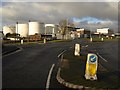
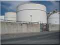
Cattedown fuel depot
Oil storage tanks at Cattedown, part of a major fuel depot, seen from Finnigan Road.
Image: © Derek Harper
Taken: 29 Jan 2010
0.08 miles
2
Fuel storage tanks, Cattedown
Fuel storage tanks viewed from Maxwell Road in Cattedown in Plymouth.
Image: © Philip Halling
Taken: 4 Jun 2011
0.10 miles
3
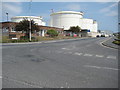
Fuel storage tanks, Cattedown
Fuel storage tanks viewed from Maxwell Road in Cattedown in Plymouth.
Image: © Philip Halling
Taken: 4 Jun 2011
0.11 miles
5
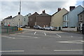
Finnigan Road
Finnigan Road nearing roundabout with Maxwell Road
Image: © Shaun Ferguson
Taken: 21 Jul 2009
0.14 miles