IMAGES TAKEN NEAR TO
Cattedown Road, PLYMOUTH, PL4 0RP
Introduction
This page details the photographs taken nearby to Cattedown Road, PL4 0RP by members of the Geograph project.
The Geograph project started in 2005 with the aim of publishing, organising and preserving representative images for every square kilometre of Great Britain, Ireland and the Isle of Man.

There are currently over 7.5m images from over14,400 individuals and you can help contribute to the project by visiting https://www.geograph.org.uk
Image Map
Images are licensed for reuse under creativecommons.org/licenses/by-sa/2.0
Notes
- Clicking on the map will re-center to the selected point.
- The higher the marker number, the further away the image location is from the centre of the postcode.
Image Listing (45 Images Found)
Images are licensed for reuse under creativecommons.org/licenses/by-sa/2.0
Image
Details
Distance
1
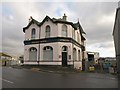
Passage House, Cattedown
The inn, on Cattedown Road, dates from the early C20, and is surrounded by marine and industrial activity.
Image: © Derek Harper
Taken: 29 Jan 2010
0.03 miles
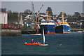
2

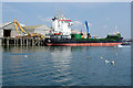
Karl-Jakob K at Plymouth
The Karl-Jakob K sits high in the water, having unloaded most of her cargo, at a wharf in Cattewater. She is a general cargo vessel built in 2006 and sails under the flag of the Netherlands. She had arrived at Plymouth a few days earlier from Ghent in Belgium and would sail for Spain later on this day.
Image: © Stephen McKay
Taken: 30 Aug 2022
0.04 miles
3

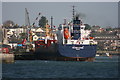
Karl-Jakob K at Plymouth
In maritime terms, Plymouth is best know for its naval dockyard and leisure boating but it also operates as a general port and here the Karl-Jakob K is in the last stages of unloading her cargo of sand or aggregates at the Cattedown wharves. The blue crane is in the process of emptying her hold. The ship is a general cargo vessel built in 2006 and sails under the flag of the Netherlands. She had arrived at Plymouth a few days earlier from Ghent in Belgium and would sail for Spain later on this day.
Image: © Stephen McKay
Taken: 30 Aug 2022
0.06 miles
4
Boston Shipyard, Oreston
Situated on the northern side of the entrance to Hooe Lake is this small family shipyard which maintains an active role in the repair of a range of vessels.
Image: © Gwyn Jones
Taken: 13 Oct 2005
0.06 miles
5
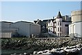
Cattedown
A late 19th century public house sits amid the large industrial sheds and silos on the Cattedown waterfront.
Image: © Tony Atkin
Taken: 15 Feb 2003
0.06 miles
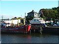
6
Cattedown Wharves
Two large fishing boats registered in Plymouth are alongside Cattedown Wharves. In the foreground is a dinghy from the Mount Batten Water Sports Centre Image with one of the safety boats in attendance.
Image: © Adrian Platt
Taken: 1 Mar 2008
0.06 miles
7
'Paul' at Cattedown Wharf
'Paul' is a general cargo merchant ship built in 1991 and currently sailing under the flag of Antigua Barbuda. She is 89.78 metres (295 feet) in length and has a carrying capacity of 4618t deadweight tonnage. She had arrived at Cattedown Wharf, part of the Port of Plymouth on the north shore of Cattewater, from Ghent in Belgium and would next sail to Wismar, Germany.
Image: © Stephen McKay
Taken: 16 Sep 2020
0.08 miles
8
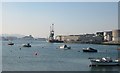
The Cattewater
The Cattewater is the lower part of the estuary of the River Plym between Laira Bridge and Plymouth Sound. This is the site of Plymouth's limited commercial and industrial port facilities. This photograph looks westward towards Mountbatten.
Image: © Tony Atkin
Taken: 15 Feb 2003
0.09 miles
9
The Solway Fisher leaving Cattedown Wharves
The Solway Fisher is seen leaving Cattedown Wharves after discharging her cargo of petroleum products into the local distribution depot that serves both Devon and Cornwall. See Image for information on this ship.
Image: © Adrian Platt
Taken: 1 Mar 2008
0.11 miles
10
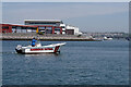
Cattewater Harbour Patrol
The patrol boat is operated by Cattewater Harbour Commissioners. It makes regular tours of the area to check on unauthorised mooring and any other untoward happenings. In the distance is Laira Bridge.
Image: © Stephen McKay
Taken: 31 May 2021
0.11 miles