IMAGES TAKEN NEAR TO
Brunswick Road, PLYMOUTH, PL4 0NP
Introduction
This page details the photographs taken nearby to Brunswick Road, PL4 0NP by members of the Geograph project.
The Geograph project started in 2005 with the aim of publishing, organising and preserving representative images for every square kilometre of Great Britain, Ireland and the Isle of Man.

There are currently over 7.5m images from over14,400 individuals and you can help contribute to the project by visiting https://www.geograph.org.uk
Image Map
Images are licensed for reuse under creativecommons.org/licenses/by-sa/2.0
Notes
- Clicking on the map will re-center to the selected point.
- The higher the marker number, the further away the image location is from the centre of the postcode.
Image Listing (245 Images Found)
Images are licensed for reuse under creativecommons.org/licenses/by-sa/2.0
Image
Details
Distance

8
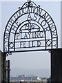
The Astor Playing Field, 1916, Plymouth
This fine wrought iron gate entrance sign to the Astor playing field, erected by the Plymouth Education Authority, is complete with a spelling mistake. Still, Shakespeare spelled words differently before rules were laid down about "correct" spellings. Or perhaps a mischievous welder has been practising.
Image: © Tom Jolliffe
Taken: 28 Mar 2007
0.07 miles