IMAGES TAKEN NEAR TO
Bretonside, PLYMOUTH, PL4 0BY
Introduction
This page details the photographs taken nearby to Bretonside, PL4 0BY by members of the Geograph project.
The Geograph project started in 2005 with the aim of publishing, organising and preserving representative images for every square kilometre of Great Britain, Ireland and the Isle of Man.

There are currently over 7.5m images from over14,400 individuals and you can help contribute to the project by visiting https://www.geograph.org.uk
Image Map
Images are licensed for reuse under creativecommons.org/licenses/by-sa/2.0
Notes
- Clicking on the map will re-center to the selected point.
- The higher the marker number, the further away the image location is from the centre of the postcode.
Image Listing (2247 Images Found)
Images are licensed for reuse under creativecommons.org/licenses/by-sa/2.0
Image
Details
Distance
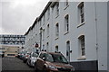
1

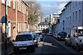
How Street, Plymouth
These four houses of flats, in a terrace of five that begins with Image, were constructed by the city corporation at about the same time as Image, the adjacent street to the south, forming "part of a complete block of practically unaltered early local authority housing" http://www.britishlistedbuildings.co.uk/en-473543-corporation-buildings-16-21-plymouth .
Image: © Derek Harper
Taken: 1 Jul 2011
0.01 miles
3
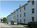
Corporation Buildings, How Street – upper group
An early example of council housing, built 1898-1901. This group consists of tenement houses of single bedroom tenements. Listed Grade II.
Image: © Alan Murray-Rust
Taken: 29 Jun 2023
0.02 miles
5
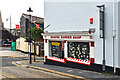
Corner barber's shop - How Street, Plymouth
On the edge of the older part of the city and adjacent to the City Centre; note the cobbled road.
Image: © Mick Lobb
Taken: 8 Jul 2009
0.02 miles
6
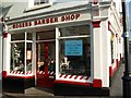
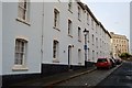
Rogers barber shop, Plymouth
At the corner of How Street and Buckwell Street (right), this forms part of the listed terrace shown in Image http://www.britishlistedbuildings.co.uk/en-473543-corporation-buildings-16-21-plymouth .
Image: © Derek Harper
Taken: 1 Jul 2011
0.02 miles
7
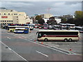
Plymouth Bus Station
Plymouth Bus Station viewed from Exeter Street.
Image: © Philip Halling
Taken: 3 Oct 2009
0.02 miles
8
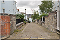
Cobbled Lane between How and Looe Streets - Plymouth
Image: © Mick Lobb
Taken: 8 Jul 2009
0.03 miles
9
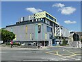
The Barcode, Bretonside, Plymouth
This is a recent retail and leisure complex (opened 2019) built on the site of a former bus station Image
Image: © Stephen Craven
Taken: 29 Jun 2023
0.03 miles
10
Corporation Buildings, Looe St
Grade II listed. http://www.britishlistedbuildings.co.uk/en-473585-corporation-buildings-
Image: © N Chadwick
Taken: 28 Mar 2015
0.03 miles