IMAGES TAKEN NEAR TO
Bretonside, PLYMOUTH, PL4 0AU
Introduction
This page details the photographs taken nearby to Bretonside, PL4 0AU by members of the Geograph project.
The Geograph project started in 2005 with the aim of publishing, organising and preserving representative images for every square kilometre of Great Britain, Ireland and the Isle of Man.

There are currently over 7.5m images from over14,400 individuals and you can help contribute to the project by visiting https://www.geograph.org.uk
Image Map
Images are licensed for reuse under creativecommons.org/licenses/by-sa/2.0
Notes
- Clicking on the map will re-center to the selected point.
- The higher the marker number, the further away the image location is from the centre of the postcode.
Image Listing (1560 Images Found)
Images are licensed for reuse under creativecommons.org/licenses/by-sa/2.0
Image
Details
Distance
8
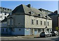
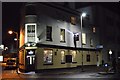
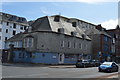
Mayflower House, Bretonside, Plymouth
Merchant's house, built 1655 but later divided into several dwellings and with the front largely rebuilt during the early 20th century. A stone plaque https://www.geograph.org.uk/photo/7536820 dated 1787 presumably refers to a former owner of the building.
Image: © Alan Murray-Rust
Taken: 29 Jun 2023
0.02 miles
9
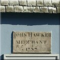
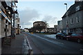
Datestone, Mayflower House, Bretonside, Plymouth
In this instance not the date of building, the house being significantly older. See https://www.geograph.org.uk/photo/7536817 for location.
Image: © Alan Murray-Rust
Taken: 29 Jun 2023
0.02 miles