IMAGES TAKEN NEAR TO
Severn Place, PLYMOUTH, PL3 6JL
Introduction
This page details the photographs taken nearby to Severn Place, PL3 6JL by members of the Geograph project.
The Geograph project started in 2005 with the aim of publishing, organising and preserving representative images for every square kilometre of Great Britain, Ireland and the Isle of Man.

There are currently over 7.5m images from over14,400 individuals and you can help contribute to the project by visiting https://www.geograph.org.uk
Image Map
Images are licensed for reuse under creativecommons.org/licenses/by-sa/2.0
Notes
- Clicking on the map will re-center to the selected point.
- The higher the marker number, the further away the image location is from the centre of the postcode.
Image Listing (6 Images Found)
Images are licensed for reuse under creativecommons.org/licenses/by-sa/2.0
Image
Details
Distance
3
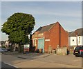
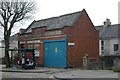
Laira library in former police and fire station
Image: © David Smith
Taken: 24 Jun 2018
0.19 miles
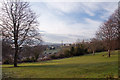
4
Efford
Looking towards the Plym estuary.
Image: © Burgess Von Thunen
Taken: 19 Sep 2012
0.21 miles
5
Laira old Police and Fire Station
Laira old Police and Fire Station, Old Laira Road, Plymouth, Devon. After use as a fire station, it was converted to a library.
Image: © Kevin Hale
Taken: 28 Feb 2007
0.21 miles
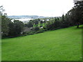
6
Green belt, Efford - Plymouth
Efford is a post war housing estate perched high on a hill overlooking the River Plym. Much of the hillside has been retained as green belt.
Image: © Mick Lobb
Taken: 31 Jan 2010
0.25 miles