IMAGES TAKEN NEAR TO
Wycliffe Road, PLYMOUTH, PL3 6BZ
Introduction
This page details the photographs taken nearby to Wycliffe Road, PL3 6BZ by members of the Geograph project.
The Geograph project started in 2005 with the aim of publishing, organising and preserving representative images for every square kilometre of Great Britain, Ireland and the Isle of Man.

There are currently over 7.5m images from over14,400 individuals and you can help contribute to the project by visiting https://www.geograph.org.uk
Image Map
Images are licensed for reuse under creativecommons.org/licenses/by-sa/2.0
Notes
- Clicking on the map will re-center to the selected point.
- The higher the marker number, the further away the image location is from the centre of the postcode.
Image Listing (28 Images Found)
Images are licensed for reuse under creativecommons.org/licenses/by-sa/2.0
Image
Details
Distance
1
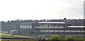
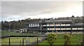
Railway through Lipson
Main railway line through Lipson, in the outskirts of Plymouth.
Image: © Wayland Smith
Taken: 26 Aug 2007
0.13 miles
3
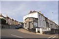
The Hair Room, Lipson Vale, Plymouth
This one storey business fills the angle between Efford Lane and Old Laira Road. It appears on the old maps of the city so was presumably built with the adjacent terrace
Image: © David Smith
Taken: 24 Jun 2018
0.19 miles