IMAGES TAKEN NEAR TO
Mannamead Road, PLYMOUTH, PL3 5QJ
Introduction
This page details the photographs taken nearby to Mannamead Road, PL3 5QJ by members of the Geograph project.
The Geograph project started in 2005 with the aim of publishing, organising and preserving representative images for every square kilometre of Great Britain, Ireland and the Isle of Man.

There are currently over 7.5m images from over14,400 individuals and you can help contribute to the project by visiting https://www.geograph.org.uk
Image Map (Loading...)


Getting Data...Please wait
Leaflet Map data © OpenStreetMap
Images are licensed for reuse under creativecommons.org/licenses/by-sa/2.0
Notes
- Clicking on the map will re-center to the selected point.
- The higher the marker number, the further away the image location is from the centre of the postcode.
Image Listing (52 Images Found)
Images are licensed for reuse under creativecommons.org/licenses/by-sa/2.0
Image
Details
Distance
3
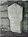
Old Boundary Marker on Mannamead Road, Plymouth
Municipal Boundary Marker set in a stone wall on the west side of the B3250 Mannamead Road, 50 metres southeast of Hartley Road. It is inscribed 1893 / C.G.L.B / R.N.W. / 16. R.N.W. was R N Worth, the chair of Compton Gifford Local Board of Health.
Milestone Society National ID: DV_CGLB04pb
Image: © T Jenkinson
Taken: 21 Sep 2011
0.04 miles