IMAGES TAKEN NEAR TO
Brynmoor Park, PLYMOUTH, PL3 5LB
Introduction
This page details the photographs taken nearby to Brynmoor Park, PL3 5LB by members of the Geograph project.
The Geograph project started in 2005 with the aim of publishing, organising and preserving representative images for every square kilometre of Great Britain, Ireland and the Isle of Man.

There are currently over 7.5m images from over14,400 individuals and you can help contribute to the project by visiting https://www.geograph.org.uk
Image Map
Images are licensed for reuse under creativecommons.org/licenses/by-sa/2.0
Notes
- Clicking on the map will re-center to the selected point.
- The higher the marker number, the further away the image location is from the centre of the postcode.
Image Listing (34 Images Found)
Images are licensed for reuse under creativecommons.org/licenses/by-sa/2.0
Image
Details
Distance
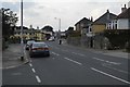
3
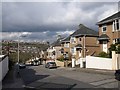
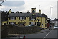
Hollycroft Road, Plymouth
Lined with semis, the road plunges into the Hartley Vale valley. On the other side is Eggbuckland.
Image: © Derek Harper
Taken: 27 Mar 2010
0.09 miles
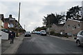
8
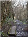
Duckboards, Hollycroft Wood
What was intended to be a purely urban walk has become a rather muddy one. The A38 Parkway, as shown in Image, runs along a wooded valley through the Plymouth suburbs. Hollycroft Wood is managed by the Woodland Trust. This stretch of path is at the foot of the wood near the stream, and the noisy dual carriageway (both off to the right).
Image: © Derek Harper
Taken: 27 Mar 2010
0.11 miles