IMAGES TAKEN NEAR TO
Trevalga, BOSCASTLE, PL35 0EF
Introduction
This page details the photographs taken nearby to PL35 0EF by members of the Geograph project.
The Geograph project started in 2005 with the aim of publishing, organising and preserving representative images for every square kilometre of Great Britain, Ireland and the Isle of Man.

There are currently over 7.5m images from over14,400 individuals and you can help contribute to the project by visiting https://www.geograph.org.uk
Image Map
Images are licensed for reuse under creativecommons.org/licenses/by-sa/2.0
Notes
- Clicking on the map will re-center to the selected point.
- The higher the marker number, the further away the image location is from the centre of the postcode.
Image Listing (7 Images Found)
Images are licensed for reuse under creativecommons.org/licenses/by-sa/2.0
Image
Details
Distance
1
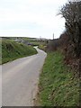
Lane to Treweens Farm
Seen from a five-way hilltop junction on the B3266, partly shown in Image This lane progresses along a ridge south of Boscastle, towards Trevalga. It is followed by the parish boundary between Trevalga (left) and Forrabury and Minster. Treweens Farm is on the next corner; the farm buildings visible beyond, with the sea on their right, are in Image
Image: © Derek Harper
Taken: 18 Mar 2008
0.02 miles
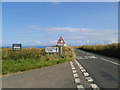
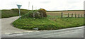
3
Five-way junction...
...where three minor roads join the B3266.
Image: © Bill Harrison
Taken: 22 Jul 2012
0.14 miles
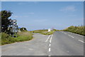
4
Junction, B3266
An update on Image The major change has been the installation of a large slate stone announcing Boscastle.
Image: © Derek Harper
Taken: 19 May 2021
0.16 miles
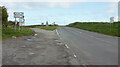
5
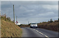
The B3266
Heading south from Boscastle.
Image: © Robert Ashby
Taken: 21 Aug 2014
0.18 miles
6
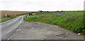
Lay-by by the B3266
Looking right from Image The road is heading for Camelford.
Image: © Derek Harper
Taken: 19 May 2021
0.19 miles
7
Road junction, B3266
Showing a part of the junction not appearing at https://www.geograph.org.uk/search.php?i=148837208 . The side road goes to Davidstow, the main road to the right is for Camelford.
Image: © Derek Harper
Taken: 19 May 2021
0.20 miles