IMAGES TAKEN NEAR TO
Lesnewth, BOSCASTLE, PL35 0BZ
Introduction
This page details the photographs taken nearby to PL35 0BZ by members of the Geograph project.
The Geograph project started in 2005 with the aim of publishing, organising and preserving representative images for every square kilometre of Great Britain, Ireland and the Isle of Man.

There are currently over 7.5m images from over14,400 individuals and you can help contribute to the project by visiting https://www.geograph.org.uk
Image Map (Loading...)


Getting Data...Please wait
Leaflet Map data © OpenStreetMap
Images are licensed for reuse under creativecommons.org/licenses/by-sa/2.0
Notes
- Clicking on the map will re-center to the selected point.
- The higher the marker number, the further away the image location is from the centre of the postcode.
Image Listing (7 Images Found)
Images are licensed for reuse under creativecommons.org/licenses/by-sa/2.0
Image
Details
Distance
1
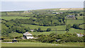
River Valency valley.
Overlooking Trebiffin with the course of the river hidden in a fold of hills.
Image: © Rabbi WP Thinrod
Taken: 8 Jun 2008
0.12 miles
3
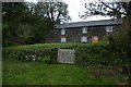
Remote house above the Valency valley
Image: © Christopher Hilton
Taken: 31 Oct 2013
0.22 miles
4
Across the Valency Valley
View towards Trafalgar from St Juliot's Church.
Image: © Gary Rogers
Taken: 22 May 2018
0.22 miles
5
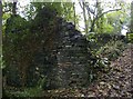
Ruin in woodland above Valency valley
Image: © Christopher Hilton
Taken: 31 Oct 2013
0.23 miles
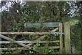
6
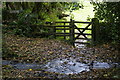
Footpath crossing stream above the Valency valley
Image: © Christopher Hilton
Taken: 31 Oct 2013
0.23 miles
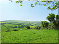
7
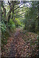
Track up the side of the Valency valley
Image: © Christopher Hilton
Taken: 31 Oct 2013
0.24 miles