IMAGES TAKEN NEAR TO
St. Juliot, BOSCASTLE, PL35 0BT
Introduction
This page details the photographs taken nearby to PL35 0BT by members of the Geograph project.
The Geograph project started in 2005 with the aim of publishing, organising and preserving representative images for every square kilometre of Great Britain, Ireland and the Isle of Man.

There are currently over 7.5m images from over14,400 individuals and you can help contribute to the project by visiting https://www.geograph.org.uk
Image Map
Images are licensed for reuse under creativecommons.org/licenses/by-sa/2.0
Notes
- Clicking on the map will re-center to the selected point.
- The higher the marker number, the further away the image location is from the centre of the postcode.
Image Listing (6 Images Found)
Images are licensed for reuse under creativecommons.org/licenses/by-sa/2.0
Image
Details
Distance
1
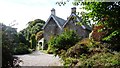
Entrance to The Old Rectory, St Juliot
Run as a Guest House/B&B. Thomas Hardy once stayed here.
Image: © Clint Mann
Taken: 30 Sep 2010
0.09 miles
2
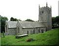
St Juliot Church nr Boscastle
St Juliot in an isolated position on the northern slopes of the Valency Valley, well worth the trek.
Thomas Hardy connections
Image: © Steve Wheeler
Taken: 6 Aug 2003
0.09 miles
4
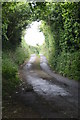
"Lane" 2011
The same "lane" as Paul McIlroy's submission, but 5 years later.
Image: © Nick Knowles
Taken: 29 May 2011
0.22 miles
5
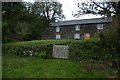
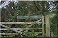
Remote house above the Valency valley
Image: © Christopher Hilton
Taken: 31 Oct 2013
0.22 miles
6
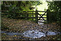
Footpath crossing stream above the Valency valley
Image: © Christopher Hilton
Taken: 31 Oct 2013
0.24 miles