IMAGES TAKEN NEAR TO
Hyde Park Road, PLYMOUTH, PL3 4RQ
Introduction
This page details the photographs taken nearby to Hyde Park Road, PL3 4RQ by members of the Geograph project.
The Geograph project started in 2005 with the aim of publishing, organising and preserving representative images for every square kilometre of Great Britain, Ireland and the Isle of Man.

There are currently over 7.5m images from over14,400 individuals and you can help contribute to the project by visiting https://www.geograph.org.uk
Image Map
Images are licensed for reuse under creativecommons.org/licenses/by-sa/2.0
Notes
- Clicking on the map will re-center to the selected point.
- The higher the marker number, the further away the image location is from the centre of the postcode.
Image Listing (103 Images Found)
Images are licensed for reuse under creativecommons.org/licenses/by-sa/2.0
Image
Details
Distance
4
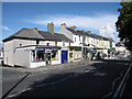
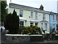
Shops on Hyde Park Road
Local shops in a residential area of Plymouth.
Image: © Hugh Venables
Taken: 7 Jun 2009
0.07 miles
5
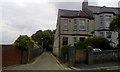
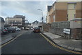
Cobbled service road off Hermitage Road, Mutley, Plymouth
Image: © David Smith
Taken: 7 May 2019
0.07 miles
6
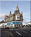
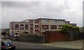
Co-op, Peverell Park Road, Plymouth
This distinctive building, on the angle between Peverell Park Road (left) and Weston Park Road, dates from about 1904.
Image: © Derek Harper
Taken: 27 Feb 2010
0.07 miles
7
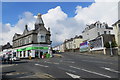
Peverell Park Road
The Co-Op store at the junction of Peverell Park Road and Weston Park Road in Plymouth.
Image: © Robert Ashby
Taken: 21 Apr 2014
0.08 miles
9
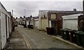
Garages in service road below Lockyer Road, Mutley
Image: © David Smith
Taken: 7 May 2019
0.09 miles
10
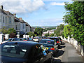
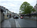
Hermitage Road
Looking towards Central Park in Plymouth.
Image: © Hugh Venables
Taken: 7 Jun 2009
0.10 miles