IMAGES TAKEN NEAR TO
Weston Park Road, PLYMOUTH, PL3 4NR
Introduction
This page details the photographs taken nearby to Weston Park Road, PL3 4NR by members of the Geograph project.
The Geograph project started in 2005 with the aim of publishing, organising and preserving representative images for every square kilometre of Great Britain, Ireland and the Isle of Man.

There are currently over 7.5m images from over14,400 individuals and you can help contribute to the project by visiting https://www.geograph.org.uk
Image Map
Images are licensed for reuse under creativecommons.org/licenses/by-sa/2.0
Notes
- Clicking on the map will re-center to the selected point.
- The higher the marker number, the further away the image location is from the centre of the postcode.
Image Listing (38 Images Found)
Images are licensed for reuse under creativecommons.org/licenses/by-sa/2.0
Image
Details
Distance
6
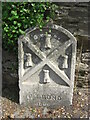
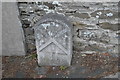
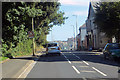
Old Boundary Marker on Burleigh Lane, Plymouth
Municipal Boundary Marker on the northwest side of Burleigh Lane, Plymouth, just east of the junction with Weston Park Road. Inscribed J.T. BOND / 1896 for John Thomas Bond, mayor.
Milestone Society National ID: DV_PCBS67pb
Image: © T Jenkinson
Taken: 21 Jul 2012
0.07 miles
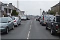
10
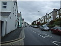
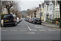
Weston Park Road
In the suburbs of Plymouth heading south-southeast
Image: © Robert Ashby
Taken: 8 Aug 2015
0.11 miles