IMAGES TAKEN NEAR TO
Peverell Park Road, PLYMOUTH, PL3 4NE
Introduction
This page details the photographs taken nearby to Peverell Park Road, PL3 4NE by members of the Geograph project.
The Geograph project started in 2005 with the aim of publishing, organising and preserving representative images for every square kilometre of Great Britain, Ireland and the Isle of Man.

There are currently over 7.5m images from over14,400 individuals and you can help contribute to the project by visiting https://www.geograph.org.uk
Image Map
Images are licensed for reuse under creativecommons.org/licenses/by-sa/2.0
Notes
- Clicking on the map will re-center to the selected point.
- The higher the marker number, the further away the image location is from the centre of the postcode.
Image Listing (26 Images Found)
Images are licensed for reuse under creativecommons.org/licenses/by-sa/2.0
Image
Details
Distance
1
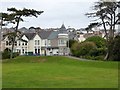
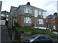
Houses and a turret in Peverell Park Road, Plymouth
Image: © David Smith
Taken: 26 Sep 2014
0.04 miles
2
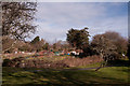
Allotments, Central Park - Plymouth
The majority of the north-east boundary of the park now holds allotments. I remember there being derelict reservoirs in the area some sixty years ago. These were the two Barn Park Reservoirs built in 1860 to they were used during World War I for emergency supplies and for fire fighting during World War II. During the post war years they were, for the most part, empty – a dangerous ‘playing ground’ for children who were attracted by the frogs and newts that bred in abundance in the shallow puddles in the cracks of the dilapidated slimy basin. Undoubtedly the reason that I remember them!
Image: © Mick Lobb
Taken: 1 Feb 2010
0.08 miles
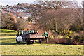
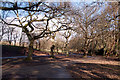
3
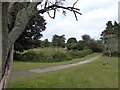
Allotments on the edge of Central Park, Plymouth
The path leads to the east side of the park, passing a large area used as allotments
Image: © David Smith
Taken: 26 Sep 2014
0.09 miles
6
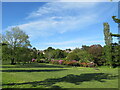
Central Park, Plymouth
Central Park is the largest park in Plymouth. It was originally created in 1928 as a park devoted to the improvement of the health of city residents. Wide boulevards go through the park's open meadows and woodlands, up and down hills with fantastic views over the city towards Plymouth Sound and Cornwall.
Image: © Richard Rogerson
Taken: 7 Jun 2021
0.13 miles
7
Mulching the shrub beds, Central Park - Plymouth
Image: © Mick Lobb
Taken: 1 Feb 2010
0.15 miles
8
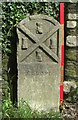
Old Boundary Marker on Venn Lane, Plymouth
Municipal Boundary Marker against a wall near a gate on Venn Lane, 250 metres west of Weston Park Road. Inscribed J.T. BOND / 1896 for John Thomas Bond, mayor.
Milestone Society National ID: DV_PCBS66pb
Image: © T Jenkinson
Taken: 21 Jul 2012
0.15 miles
10
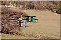
Guitarist in Central Park - Plymouth
A beautiful place in which to practice.
Image: © Mick Lobb
Taken: 1 Feb 2010
0.17 miles