IMAGES TAKEN NEAR TO
Springfield Drive, PLYMOUTH, PL3 4DU
Introduction
This page details the photographs taken nearby to Springfield Drive, PL3 4DU by members of the Geograph project.
The Geograph project started in 2005 with the aim of publishing, organising and preserving representative images for every square kilometre of Great Britain, Ireland and the Isle of Man.

There are currently over 7.5m images from over14,400 individuals and you can help contribute to the project by visiting https://www.geograph.org.uk
Image Map
Images are licensed for reuse under creativecommons.org/licenses/by-sa/2.0
Notes
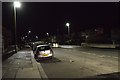
- Clicking on the map will re-center to the selected point.
- The higher the marker number, the further away the image location is from the centre of the postcode.
Image Listing (68 Images Found)
Images are licensed for reuse under creativecommons.org/licenses/by-sa/2.0
Image
Details
Distance
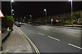
6
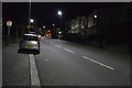
Plymouth : Salisbury Ope
Looking along Salisbury Ope off Milehouse Road.
Image: © Lewis Clarke
Taken: 17 Mar 2020
0.10 miles
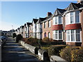
7
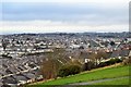
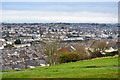
View from Mount Pleasant - NE
The rooftops of Milehouse
Image: © N Chadwick
Taken: 7 Jan 2017
0.11 miles
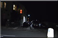
8
View from Mount Pleasant - ENE
Rooftops of Milehouse and Stoke.
Image: © N Chadwick
Taken: 7 Jan 2017
0.15 miles
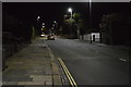
9
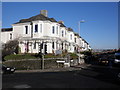
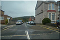
Road junction, at the top of Ford Hill, Plymouth
Image: © Roger Cornfoot
Taken: 2 Jan 2010
0.16 miles