IMAGES TAKEN NEAR TO
Church Street, PLYMOUTH, PL3 4DT
Introduction
This page details the photographs taken nearby to Church Street, PL3 4DT by members of the Geograph project.
The Geograph project started in 2005 with the aim of publishing, organising and preserving representative images for every square kilometre of Great Britain, Ireland and the Isle of Man.

There are currently over 7.5m images from over14,400 individuals and you can help contribute to the project by visiting https://www.geograph.org.uk
Image Map (Loading...)


Getting Data...Please wait
Leaflet Map data © OpenStreetMap
Images are licensed for reuse under creativecommons.org/licenses/by-sa/2.0
Notes
- Clicking on the map will re-center to the selected point.
- The higher the marker number, the further away the image location is from the centre of the postcode.
Image Listing (164 Images Found)
Images are licensed for reuse under creativecommons.org/licenses/by-sa/2.0
Image
Details
Distance
5
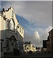
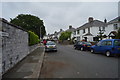
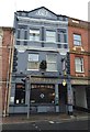
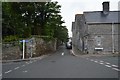
Road in Stoke, Plymouth
On the left is the St Aubyn Masonic Hall - the square and compasses symbol of Freemasonry can be seen in the Dutch gable. This view is from Devonport Road, the B3396, as it bends right in the village. Ahead is Church Street.
Image: © Derek Harper
Taken: 15 Feb 2014
0.03 miles