IMAGES TAKEN NEAR TO
Underhill Road, PLYMOUTH, PL3 4BP
Introduction
This page details the photographs taken nearby to Underhill Road, PL3 4BP by members of the Geograph project.
The Geograph project started in 2005 with the aim of publishing, organising and preserving representative images for every square kilometre of Great Britain, Ireland and the Isle of Man.

There are currently over 7.5m images from over14,400 individuals and you can help contribute to the project by visiting https://www.geograph.org.uk
Image Map (Loading...)


Getting Data...Please wait
Leaflet Map data © OpenStreetMap
Images are licensed for reuse under creativecommons.org/licenses/by-sa/2.0
Notes
- Clicking on the map will re-center to the selected point.
- The higher the marker number, the further away the image location is from the centre of the postcode.
Image Listing (158 Images Found)
Images are licensed for reuse under creativecommons.org/licenses/by-sa/2.0
Image
Details
Distance
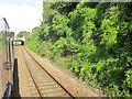
8
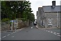
Railway west from The Elms bridge
The bridge in the background is Devonport Road; beyond it round the curve is Devonport station.
Image: © Stephen Craven
Taken: 27 Jun 2023
0.07 miles
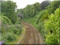
10
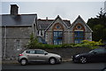
Railway bridge on The Elms
The skew bridge takes the road over the Cornish main line out of Plymouth. The panels of the iron parapet is painted with cameos. A driver's eye view (almost) is given at Image
Image: © Stephen Craven
Taken: 27 Jun 2023
0.07 miles