IMAGES TAKEN NEAR TO
The Grove, PLYMOUTH, PL3 4AL
Introduction
This page details the photographs taken nearby to The Grove, PL3 4AL by members of the Geograph project.
The Geograph project started in 2005 with the aim of publishing, organising and preserving representative images for every square kilometre of Great Britain, Ireland and the Isle of Man.

There are currently over 7.5m images from over14,400 individuals and you can help contribute to the project by visiting https://www.geograph.org.uk
Image Map (Loading...)


Getting Data...Please wait
Leaflet Map data © OpenStreetMap
Images are licensed for reuse under creativecommons.org/licenses/by-sa/2.0
Notes
- Clicking on the map will re-center to the selected point.
- The higher the marker number, the further away the image location is from the centre of the postcode.
Image Listing (123 Images Found)
Images are licensed for reuse under creativecommons.org/licenses/by-sa/2.0
Image
Details
Distance
4
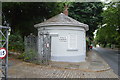
Lodge, Penlee Gardens
Grade II listed. https://britishlistedbuildings.co.uk/101386328-lodge-and-gates-at-entrance-including-flanking-wall-stoke-ward
Image: © N Chadwick
Taken: 31 May 2018
0.06 miles
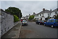
7
Somerset Place, Stoke, Plymouth
The semis on the right are on Somerset Place, but the white C19 villa is on Molesworth Road: "a complete semi-detached pair of villas in the Classical tradition" http://list.english-heritage.org.uk/resultsingle.aspx?uid=1386251&searchtype=mapsearch .
Image: © Derek Harper
Taken: 15 Feb 2014
0.07 miles