IMAGES TAKEN NEAR TO
Molesworth Road, PLYMOUTH, PL3 4AJ
Introduction
This page details the photographs taken nearby to Molesworth Road, PL3 4AJ by members of the Geograph project.
The Geograph project started in 2005 with the aim of publishing, organising and preserving representative images for every square kilometre of Great Britain, Ireland and the Isle of Man.

There are currently over 7.5m images from over14,400 individuals and you can help contribute to the project by visiting https://www.geograph.org.uk
Image Map
Images are licensed for reuse under creativecommons.org/licenses/by-sa/2.0
Notes
- Clicking on the map will re-center to the selected point.
- The higher the marker number, the further away the image location is from the centre of the postcode.
Image Listing (133 Images Found)
Images are licensed for reuse under creativecommons.org/licenses/by-sa/2.0
Image
Details
Distance
4
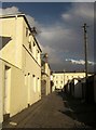
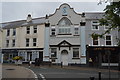
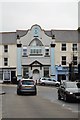
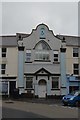
Somerset Place Lane, Stoke, Plymouth
A back street that leads from Church Street to Molesworth Road, where the white stucco terrace is described as "a robust Classical design in the stucco tradition http://list.english-heritage.org.uk/resultsingle.aspx?uid=1386252&searchtype=mapsearch .
Image: © Derek Harper
Taken: 15 Feb 2014
0.05 miles
5
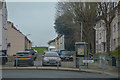
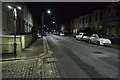
Plymouth : Packington Street
Looking along Packington Street off Ford Hill.
Image: © Lewis Clarke
Taken: 17 Mar 2020
0.05 miles