IMAGES TAKEN NEAR TO
Tregatta, TINTAGEL, PL34 0DY
Introduction
This page details the photographs taken nearby to PL34 0DY by members of the Geograph project.
The Geograph project started in 2005 with the aim of publishing, organising and preserving representative images for every square kilometre of Great Britain, Ireland and the Isle of Man.

There are currently over 7.5m images from over14,400 individuals and you can help contribute to the project by visiting https://www.geograph.org.uk
Image Map (Loading...)


Getting Data...Please wait
Leaflet Map data © OpenStreetMap
Images are licensed for reuse under creativecommons.org/licenses/by-sa/2.0
Notes
- Clicking on the map will re-center to the selected point.
- The higher the marker number, the further away the image location is from the centre of the postcode.
Image Listing (5 Images Found)
Images are licensed for reuse under creativecommons.org/licenses/by-sa/2.0
Image
Details
Distance
1
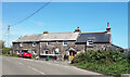
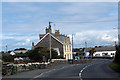
Manor House For Sale
One of the handful of houses in the hamlet of Tregatta.
Image: © Des Blenkinsopp
Taken: 27 May 2021
0.02 miles
2
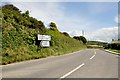
North Cornwall : The B3263
The B3263 between Camelford and Tintagel.
Image: © Lewis Clarke
Taken: 1 Jul 2011
0.04 miles
4
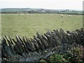
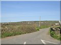
Inland view from near Hole Beach
Looking south-east towards Treknow village. The field boundaries here are all made of slate, neatly piled in fishbone patterns. Many were built as a by-product of the extensive 19th century slate mining.
Image: © Trevor Rickard
Taken: 12 Sep 2007
0.18 miles