IMAGES TAKEN NEAR TO
Reservoir Close, DELABOLE, PL33 9EL
Introduction
This page details the photographs taken nearby to Reservoir Close, PL33 9EL by members of the Geograph project.
The Geograph project started in 2005 with the aim of publishing, organising and preserving representative images for every square kilometre of Great Britain, Ireland and the Isle of Man.

There are currently over 7.5m images from over14,400 individuals and you can help contribute to the project by visiting https://www.geograph.org.uk
Image Map
Images are licensed for reuse under creativecommons.org/licenses/by-sa/2.0
Notes
- Clicking on the map will re-center to the selected point.
- The higher the marker number, the further away the image location is from the centre of the postcode.
Image Listing (29 Images Found)
Images are licensed for reuse under creativecommons.org/licenses/by-sa/2.0
Image
Details
Distance
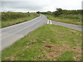
1
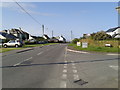
B3314 heading south in Delabole, Westdown Road to the right
Image: © Rob Purvis
Taken: 4 Aug 2014
0.07 miles
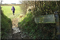
3
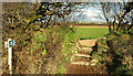
Stile near Delabole
Footpath 554 12/1 leaves Treligga Downs Road to cross a field to the stile shown in Image
Image: © Derek Harper
Taken: 5 Feb 2018
0.12 miles
4
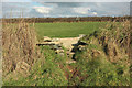
Stile near Delabole
A slate stile where footpath 554 12/1 crosses a Cornish hedge. The just visible row of chimney pots is on a row of houses on Green Lane.
Image: © Derek Harper
Taken: 5 Feb 2018
0.14 miles
5
Footpath to Treligga
Footpath 554 12/1 leaves the spot where Image] was taken and where five paths meet. The houses across the field are on Treligga Downs Road and in Image
Image: © Derek Harper
Taken: 5 Feb 2018
0.16 miles
6
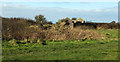
Ruins near Delabole
Seen from footpath 554 12/1. The ruins are part of a World War II RAF radio station, part of 80 Signals Wing which jammed radio signals used by German bombers (thanks to John Anderson for this information).
Image: © Derek Harper
Taken: 5 Feb 2018
0.16 miles
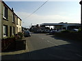
7
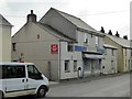
Former shop in Delabole
The former Delabole Stores beside the B3314
Image: © David Smith
Taken: 29 Sep 2014
0.18 miles
8
Treligga Downs
This wind swept road leads to Higher Pengelly and the increasing house building of Delabole. Behind the photographer is the Poldark Inn.
Image: © William Bartlett
Taken: 2 Aug 2007
0.19 miles
9
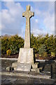
War Memorial, Delabole
War Memorial in the village of Delabole.
Image: © Philip Halling
Taken: 19 Feb 2012
0.19 miles
10
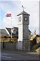
Millennium Clock Tower
Millennium clock tower beside the B3314 in Delabole. A plaque on this clock tower reads: 'Presented by St Teath Parish Council Millennium Celebrations July 2000, unveiled by George Hamilton managing director of The Delabole Slate Company'.
Image: © Philip Halling
Taken: 19 Feb 2012
0.19 miles