IMAGES TAKEN NEAR TO
Trehaze-Na Close, CAMELFORD, PL32 9YL
Introduction
This page details the photographs taken nearby to Trehaze-Na Close, PL32 9YL by members of the Geograph project.
The Geograph project started in 2005 with the aim of publishing, organising and preserving representative images for every square kilometre of Great Britain, Ireland and the Isle of Man.

There are currently over 7.5m images from over14,400 individuals and you can help contribute to the project by visiting https://www.geograph.org.uk
Image Map
Images are licensed for reuse under creativecommons.org/licenses/by-sa/2.0
Notes
- Clicking on the map will re-center to the selected point.
- The higher the marker number, the further away the image location is from the centre of the postcode.
Image Listing (6 Images Found)
Images are licensed for reuse under creativecommons.org/licenses/by-sa/2.0
Image
Details
Distance
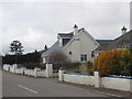
1
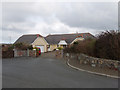
Trehaze-na Close, Marshgate
A small new close of bungalows.
Image: © David Hawgood
Taken: 28 Feb 2008
0.04 miles
2
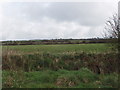
Fields by Marshgate
View from the corner of Trehaze-na Close.
Image: © David Hawgood
Taken: 28 Feb 2008
0.05 miles
3
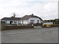
House in Marshgate with jam and pickles for sale
See Image for close-up of the yellow barrow which is the "shop".
Image: © David Hawgood
Taken: 28 Feb 2008
0.07 miles
4
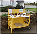
Jam and pickle "honesty box" stall, Marshgate
A very well organised retail outlet. The whole "shop" can be wheeled back from the road to the house. One notice is a hygiene certificate, the other describes the wares and lists some of the prizes won. To buy you just take the goods and leave the money in the cash box. I bought green bean chutney, which is excellent - surprisingly sweet.
Image: © David Hawgood
Taken: 28 Feb 2008
0.07 miles
5
Houses in Marshgate with monkey-puzzle tree
The house beyond is a semi-bungalow, the roof slopes down to the top of the ground floor, but there are rooms within the sloping roof space.
Image: © David Hawgood
Taken: 28 Feb 2008
0.11 miles
6
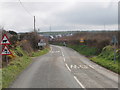
Edge of Marshgate
The photo shows the 30 mph speed limit signs on the road into Marshgate, also signs warning of cattle, and of slippery roads. Houses of the village can be seen beyond.
Image: © David Hawgood
Taken: 28 Feb 2008
0.22 miles