IMAGES TAKEN NEAR TO
CAMELFORD, PL32 9XJ
Introduction
This page details the photographs taken nearby to PL32 9XJ by members of the Geograph project.
The Geograph project started in 2005 with the aim of publishing, organising and preserving representative images for every square kilometre of Great Britain, Ireland and the Isle of Man.

There are currently over 7.5m images from over14,400 individuals and you can help contribute to the project by visiting https://www.geograph.org.uk
Image Map (Loading...)


Getting Data...Please wait
Leaflet Map data © OpenStreetMap
Images are licensed for reuse under creativecommons.org/licenses/by-sa/2.0
Notes
- Clicking on the map will re-center to the selected point.
- The higher the marker number, the further away the image location is from the centre of the postcode.
Image Listing (4 Images Found)
Images are licensed for reuse under creativecommons.org/licenses/by-sa/2.0
Image
Details
Distance
1
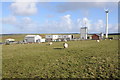
Wind turbine at Higher Parklands
The site of this wind turbine at Higher Parklands is marked on the OS map as a Water Works.
Image: © Philip Halling
Taken: 19 Feb 2012
0.02 miles
2
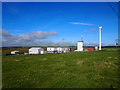
Lowermoor Water Treatment Works
Supplied by Crowdy Reservoir.
Image: © Chris Andrews
Taken: 25 Sep 2017
0.02 miles
3
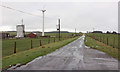
Road past Lowermoor Water Treatment Works
Image: © Derek Harper
Taken: 29 Jan 2018
0.07 miles
4
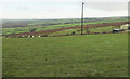
Fields near Parkwalls
Image: © Derek Harper
Taken: 29 Jan 2018
0.16 miles