IMAGES TAKEN NEAR TO
CAMELFORD, PL32 9XE
Introduction
This page details the photographs taken nearby to PL32 9XE by members of the Geograph project.
The Geograph project started in 2005 with the aim of publishing, organising and preserving representative images for every square kilometre of Great Britain, Ireland and the Isle of Man.

There are currently over 7.5m images from over14,400 individuals and you can help contribute to the project by visiting https://www.geograph.org.uk
Image Map (Loading...)


Getting Data...Please wait
Leaflet Map data © OpenStreetMap
Images are licensed for reuse under creativecommons.org/licenses/by-sa/2.0
Notes
- Clicking on the map will re-center to the selected point.
- The higher the marker number, the further away the image location is from the centre of the postcode.
Image Listing (2 Images Found)
Images are licensed for reuse under creativecommons.org/licenses/by-sa/2.0
Image
Details
Distance
1
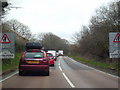
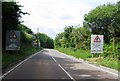
Welcome to Camelford!
Easter Monday Bank Holiday traffic queueing on the A39 Atlantic Highway to get through Camelford. There is a pinch point in the town centre where traffic lights regulate the traffic flow because it's not possible for vehicles to pass in opposite directions. This causes considerable tailbacks at busy times.
Image: © Rod Allday
Taken: 5 Apr 2010
0.16 miles