IMAGES TAKEN NEAR TO
Trevia, CAMELFORD, PL32 9UX
Introduction
This page details the photographs taken nearby to PL32 9UX by members of the Geograph project.
The Geograph project started in 2005 with the aim of publishing, organising and preserving representative images for every square kilometre of Great Britain, Ireland and the Isle of Man.

There are currently over 7.5m images from over14,400 individuals and you can help contribute to the project by visiting https://www.geograph.org.uk
Image Map
Images are licensed for reuse under creativecommons.org/licenses/by-sa/2.0
Notes
- Clicking on the map will re-center to the selected point.
- The higher the marker number, the further away the image location is from the centre of the postcode.
Image Listing (6 Images Found)
Images are licensed for reuse under creativecommons.org/licenses/by-sa/2.0
Image
Details
Distance
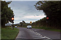
1
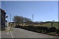
Country Road near Trevia Walls
Looking southeast past the high tension powerline which skirts the western edge of Camelford.
Image: © Tony Atkin
Taken: 7 Mar 2010
0.18 miles
2
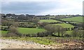
Allen valley below Trevia
Bushes and trees line field boundaries crossing the hillside on the east side of the River Allen below Trevia, which can be seen above; the centre of the village is towards the left. A small stream follows the central field boundary towards the camera; the lane from which this was taken (at Hendra) continues up the slope to the right of the barns. The area in the foreground looks as if some development might be about to take place on it.
Image: © Derek Harper
Taken: 18 Mar 2008
0.20 miles
3
A Stone Cross
This small stone cross sits at a road junction on the outskirts of Camelford.
Image: © Tony Atkin
Taken: 7 Mar 2010
0.21 miles
4
Old Wayside Cross
Trevia Cross, a wayside cross, with an old head & neck. Set at the junction of the B3266 and Clease Road. Camelford parish. Langdon NC No. 60. A Scheduled Monument https://historicengland.org.uk/listing/the-list/list-entry/1007967. See also http://www.geograph.org.uk/photo/1755022.
Milestone Society National ID: CWNC_CAM05
Image: © L Nott
Taken: 19 Oct 2019
0.21 miles
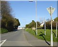
5
Near Camelford
The B3266 approaching Camelford.
Image: © Robert Ashby
Taken: 21 Aug 2014
0.22 miles
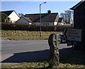
6
Clease Road, Camelford
This road links the B3266 with the A39
Image: © David Smith
Taken: 18 Apr 2018
0.25 miles