IMAGES TAKEN NEAR TO
Trevia, CAMELFORD, PL32 9UU
Introduction
This page details the photographs taken nearby to PL32 9UU by members of the Geograph project.
The Geograph project started in 2005 with the aim of publishing, organising and preserving representative images for every square kilometre of Great Britain, Ireland and the Isle of Man.

There are currently over 7.5m images from over14,400 individuals and you can help contribute to the project by visiting https://www.geograph.org.uk
Image Map
Images are licensed for reuse under creativecommons.org/licenses/by-sa/2.0
Notes
- Clicking on the map will re-center to the selected point.
- The higher the marker number, the further away the image location is from the centre of the postcode.
Image Listing (13 Images Found)
Images are licensed for reuse under creativecommons.org/licenses/by-sa/2.0
Image
Details
Distance
1
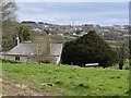
View at Hendra
Hendra House seen from the lane from Trewen, with Trevia across the valley of the River Allen.
Image: © Derek Harper
Taken: 18 Mar 2008
0.03 miles
2
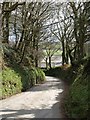
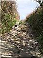
Lane at Hendra
The lane to the right of the junction shown in Image, winding down into the Allen valley between high banks and trees. Hendra House can be seen.
Image: © Derek Harper
Taken: 18 Mar 2008
0.04 miles
3
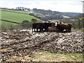
Cattle at Hendra
A muddy lunch spot for these cattle, seen from the same place as Image was taken, looking more to the right. In the background is the valley of the Allen heading downstream. Juliot's Well Holiday Park, on the far side, is in SX0982.
Image: © Derek Harper
Taken: 18 Mar 2008
0.04 miles
4
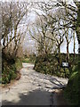
Lane junction, Hendra
Hendra, meaning "old farm", is a common Cornish place name. Here the lane north of Trewen meets, at a double bend, a lane climbing the west slopes of the Allen valley on its way from Camelford to Delabole.
Image: © Derek Harper
Taken: 18 Mar 2008
0.07 miles
5
Cat on a track, Hendra
The cat is actually not far from civilisation; this field access track continues the line of the lane from which Image was taken, and is from the same junction.
Image: © Derek Harper
Taken: 18 Mar 2008
0.07 miles
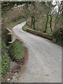
6
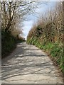
Lane to Delabole
Taken from the same corner as Image Having negotiated the double bend (see ), the lane continues to climb the western side of the Allen valley.
Image: © Derek Harper
Taken: 18 Mar 2008
0.09 miles
7
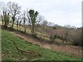
Field by the River Allen
Looking in the opposite direction from Image, therefore upstream.
Image: © Derek Harper
Taken: 18 Mar 2008
0.10 miles
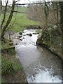
8
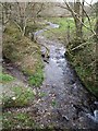
River Allen
Looking up the little stream, scarcely a river here, from Trewen Bridge.
Image: © Derek Harper
Taken: 18 Mar 2008
0.13 miles
9
Trewen Bridge
The lane from Hendra to Trevia crosses the River Allen. Image and Image were both taken from this bridge.
Image: © Derek Harper
Taken: 18 Mar 2008
0.14 miles
10
River Allen
Looking downstream from Trewen Bridge. For the upstream view, see Image
Image: © Derek Harper
Taken: 18 Mar 2008
0.16 miles