IMAGES TAKEN NEAR TO
Trefrew Road, CAMELFORD, PL32 9TP
Introduction
This page details the photographs taken nearby to Trefrew Road, PL32 9TP by members of the Geograph project.
The Geograph project started in 2005 with the aim of publishing, organising and preserving representative images for every square kilometre of Great Britain, Ireland and the Isle of Man.

There are currently over 7.5m images from over14,400 individuals and you can help contribute to the project by visiting https://www.geograph.org.uk
Image Map (Loading...)


Getting Data...Please wait
Leaflet Map data © OpenStreetMap
Images are licensed for reuse under creativecommons.org/licenses/by-sa/2.0
Notes
- Clicking on the map will re-center to the selected point.
- The higher the marker number, the further away the image location is from the centre of the postcode.
Image Listing (45 Images Found)
Images are licensed for reuse under creativecommons.org/licenses/by-sa/2.0
Image
Details
Distance
1
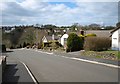
Warrens Field, Camelford
Modern bungalows in a northern suburb of Camelford; the cul-de-sac off Trefrew Road curves down into the Camel valley. On the far side are houses on Mill Lane.
Image: © Derek Harper
Taken: 18 Mar 2008
0.02 miles
2
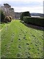
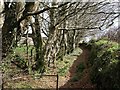
Footpath near Camelford
A grassy footpath (507/17/3) within the leafy northern suburbs of Camelford; it runs between the backs of properties on Trefrew Road (left) and Warrens Field (right) and leads down towards the Camel and the centre of town.
Image: © Derek Harper
Taken: 18 Mar 2008
0.02 miles
3

Trefrew Road, Camelford
The last houses before the lane reaches the countryside. Taken from close to the junction with Warrens Field.
Image: © Derek Harper
Taken: 18 Mar 2008
0.05 miles
4
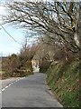
Trefrew Road, Camelford
Taken a little further along Image, with the road becoming a rural lane. Just visible is a house at the beginning of the hamlet of Trefrew.
Image: © Derek Harper
Taken: 18 Mar 2008
0.08 miles
5
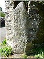
Old Milestone by Trefrew Road, Camelford
Carved stone post by the UC road, in parish of CAMELFORD (NORTH CORNWALL District), Middle Warren, Trefrew Road, at apex of two driveway walls, at road edge, on West side of road. Erected by the parish in the 18th century.
Inscription reads:-
I
Mile
To
Camel
ford
1752
Cornwall & Scilly HER.
HER Number: MCO56179 https://www.heritagegateway.org.uk/Gateway/Results_Single.aspx?uid=MCO56179&resourceID=1020
Milestone Society National ID: CW_CF01
Image: © Rosy Hanns
Taken: 19 Apr 2019
0.08 miles
6
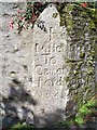
Old Milestone by Trefrew Road, Camelford
Carved stone post by the UC road, in parish of CAMELFORD (NORTH CORNWALL District), Middle Warren, Trefrew Road, at apex of two driveway walls, at road edge, on West side of road. Erected by the parish in the 18th century.
Inscription reads:-
I
Mile
To
Camel
ford
1752
Milestone Society National ID: CW_CF01.
Image: © Ian Thompson
Taken: 28 Aug 2010
0.09 miles
7
Private path off Trefrew Road
A tempting path leading away beside beech trees from Trefrew Road, but off-limits.
Image: © Derek Harper
Taken: 18 Mar 2008
0.09 miles

9
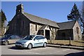
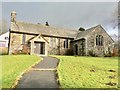
The Church of St. Thomas of Canterbury
A small church by the car park.
Image: © Tony Atkin
Taken: 7 Mar 2010
0.11 miles