IMAGES TAKEN NEAR TO
Anvil Road, CAMELFORD, PL32 9TG
Introduction
This page details the photographs taken nearby to Anvil Road, PL32 9TG by members of the Geograph project.
The Geograph project started in 2005 with the aim of publishing, organising and preserving representative images for every square kilometre of Great Britain, Ireland and the Isle of Man.

There are currently over 7.5m images from over14,400 individuals and you can help contribute to the project by visiting https://www.geograph.org.uk
Image Map
Images are licensed for reuse under creativecommons.org/licenses/by-sa/2.0
Notes
- Clicking on the map will re-center to the selected point.
- The higher the marker number, the further away the image location is from the centre of the postcode.
Image Listing (66 Images Found)
Images are licensed for reuse under creativecommons.org/licenses/by-sa/2.0
Image
Details
Distance
2
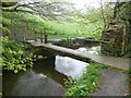
Footbridge, Camelford
On the riverside path that is signposted to Advent Church.
Image: © Humphrey Bolton
Taken: 6 May 2009
0.04 miles
3

Flats on the High Street (the A39)
An imposing block, maybe a former warehouse?
Image: © Bill Harrison
Taken: 10 Jul 2012
0.04 miles
5
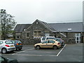
Car park and Solid Rock Cafe, Clease Meadows, Camelford
Image: © Rob Purvis
Taken: 16 May 2010
0.05 miles
6
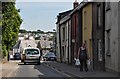
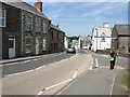
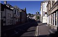
Camelford : A39 High Street
The High Street through Camelford.
Image: © Lewis Clarke
Taken: 4 Jul 2011
0.06 miles
7
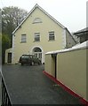
The Old Chapel, Camelford
Now a residential property.
Image: © Humphrey Bolton
Taken: 6 May 2009
0.06 miles
8
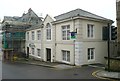
Lloyds TSB Bank, Camelford
Looking very smart.
Image: © Humphrey Bolton
Taken: 6 May 2009
0.06 miles
9
Camelford
Early morning in the centre of the Town
Image: © Chris Heaton
Taken: 25 May 1997
0.06 miles