IMAGES TAKEN NEAR TO
Longfield Drive, CAMELFORD, PL32 9TE
Introduction
This page details the photographs taken nearby to Longfield Drive, PL32 9TE by members of the Geograph project.
The Geograph project started in 2005 with the aim of publishing, organising and preserving representative images for every square kilometre of Great Britain, Ireland and the Isle of Man.

There are currently over 7.5m images from over14,400 individuals and you can help contribute to the project by visiting https://www.geograph.org.uk
Image Map
Images are licensed for reuse under creativecommons.org/licenses/by-sa/2.0
Notes
- Clicking on the map will re-center to the selected point.
- The higher the marker number, the further away the image location is from the centre of the postcode.
Image Listing (7 Images Found)
Images are licensed for reuse under creativecommons.org/licenses/by-sa/2.0
Image
Details
Distance
1
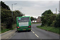
The B3266
A local bus going about its business in Camelford.
Image: © Robert Ashby
Taken: 21 Aug 2014
0.09 miles
2
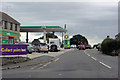
The B3266
Service station and minimarket on the outskirts of Camelford.
Image: © Robert Ashby
Taken: 21 Aug 2014
0.16 miles
3
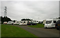
Camelford Caravan Club Site formerly Valley Truckle Caravan Club Site Camelford
Image: © Jo and Steve Turner
Taken: 17 Jun 2005
0.21 miles
4
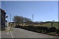
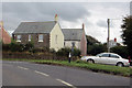
Country Road near Trevia Walls
Looking southeast past the high tension powerline which skirts the western edge of Camelford.
Image: © Tony Atkin
Taken: 7 Mar 2010
0.21 miles
5
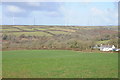
View to Delabole Wind Farm
View to Delabole Wind Farm from above Hendra.
Image: © Philip Halling
Taken: 19 Feb 2012
0.21 miles
6
Road Junction
The B 3266 leaving Camelford.
Image: © Robert Ashby
Taken: 21 Aug 2014
0.22 miles
7
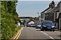
Camelford : A39 High Street
The High Street through Camelford on the A39.
Image: © Lewis Clarke
Taken: 4 Jul 2011
0.22 miles