IMAGES TAKEN NEAR TO
Tresparrett Posts, CAMELFORD, PL32 9SP
Introduction
This page details the photographs taken nearby to PL32 9SP by members of the Geograph project.
The Geograph project started in 2005 with the aim of publishing, organising and preserving representative images for every square kilometre of Great Britain, Ireland and the Isle of Man.

There are currently over 7.5m images from over14,400 individuals and you can help contribute to the project by visiting https://www.geograph.org.uk
Image Map
Images are licensed for reuse under creativecommons.org/licenses/by-sa/2.0
Notes
- Clicking on the map will re-center to the selected point.
- The higher the marker number, the further away the image location is from the centre of the postcode.
Image Listing (3 Images Found)
Images are licensed for reuse under creativecommons.org/licenses/by-sa/2.0
Image
Details
Distance
1
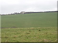
Fields by Wilslea Farm
Wilslea Farm is on the skyline; the view is from the road to Pencuke.
Image: © David Hawgood
Taken: 28 Feb 2008
0.02 miles
2
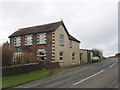
Wilslea Farm
Nearby Cansford Farm has a sign saying it has Jersey cows, and has a history back to 1542.
Image: © David Hawgood
Taken: 28 Feb 2008
0.05 miles
3
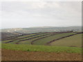
Narrow hedged fields run down to a stream
Each field is about 100 metres wide at the top by a road, but they curve together and become narrower by the stream so each is only about 30 metres wide there.
Image: © David Hawgood
Taken: 28 Feb 2008
0.25 miles