IMAGES TAKEN NEAR TO
CAMELFORD, PL32 9RH
Introduction
This page details the photographs taken nearby to PL32 9RH by members of the Geograph project.
The Geograph project started in 2005 with the aim of publishing, organising and preserving representative images for every square kilometre of Great Britain, Ireland and the Isle of Man.

There are currently over 7.5m images from over14,400 individuals and you can help contribute to the project by visiting https://www.geograph.org.uk
Image Map (Loading...)


Getting Data...Please wait
Leaflet Map data © OpenStreetMap
Images are licensed for reuse under creativecommons.org/licenses/by-sa/2.0
Notes
- Clicking on the map will re-center to the selected point.
- The higher the marker number, the further away the image location is from the centre of the postcode.
Image Listing (2 Images Found)
Images are licensed for reuse under creativecommons.org/licenses/by-sa/2.0
Image
Details
Distance
1
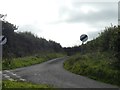
Derestricted road, but not one to speed on
The minor road to Treveighan from B3266
Image: © David Smith
Taken: 7 Sep 2020
0.15 miles
2
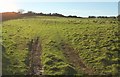
Outwork, Helsbury Castle
Like Image, this looks up the eastern slopes of Michaelstow Beacon to the univallate hillfort described at https://www.historicengland.org.uk/listing/the-list/list-entry/1006707 . "There is a rectangular outwork to the east which measures approximately 100m long by 40m wide. A distinct hollow way runs through the entrance of the outwork and parts of the rampart". The earthworks are picked out in the winter afternoon sunshine. See also Image
Image: © Derek Harper
Taken: 25 Jan 2017
0.25 miles