IMAGES TAKEN NEAR TO
Advent, CAMELFORD, PL32 9QR
Introduction
This page details the photographs taken nearby to PL32 9QR by members of the Geograph project.
The Geograph project started in 2005 with the aim of publishing, organising and preserving representative images for every square kilometre of Great Britain, Ireland and the Isle of Man.

There are currently over 7.5m images from over14,400 individuals and you can help contribute to the project by visiting https://www.geograph.org.uk
Image Map (Loading...)


Getting Data...Please wait
Leaflet Map data © OpenStreetMap
Images are licensed for reuse under creativecommons.org/licenses/by-sa/2.0
Notes
- Clicking on the map will re-center to the selected point.
- The higher the marker number, the further away the image location is from the centre of the postcode.
Image Listing (10 Images Found)
Images are licensed for reuse under creativecommons.org/licenses/by-sa/2.0
Image
Details
Distance
1
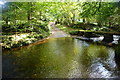
Trecarne Ford
This ford and clapper bridge are found on the River Camel at Trecarne. The Camelford Way crosses at this point.
https://youtu.be/13K3PqX61NE
Image: © John Walton
Taken: 19 Sep 2015
0.02 miles
2
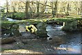
Clapper bridge, Trecarne
Also visible in Image, and across the Stannon Stream. "Bridge constructed of large slabs of granite supported on 2 large piers and 1 smaller pier of granite and moorstone" https://www.historicengland.org.uk/listing/the-list/list-entry/1142752 . Both the Camelford Way and the Moorland Walk cross the bridge.
Image: © Derek Harper
Taken: 25 Jan 2017
0.04 miles
3
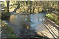
Ford, Trecarne
Seen from the clapper bridge shown in Image The river is named the Stannon Stream by the Environment Agency at http://environment.data.gov.uk/catchment-planning/WaterBody/GB108049007040 .
Image: © Derek Harper
Taken: 25 Jan 2017
0.04 miles
4
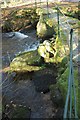
Clapper bridge, Trecarne
Looking along the bridge https://www.historicengland.org.uk/listing/the-list/list-entry/1142752 shown in Image
Image: © Derek Harper
Taken: 25 Jan 2017
0.04 miles
5
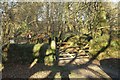
Gate to the ford, Trecarne
Looking left from where Image] was taken, with the route with public access used by the Moorland Walk and the Camelford Way passing through a gate to reach the ford and footbridge shown in Image
Image: © Derek Harper
Taken: 25 Jan 2017
0.05 miles
6
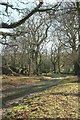
Public access route to Henon
Just south of the ford and footbridge shown in Image Both the Camelford Way and the Moorland Walk use this track to follow the east side of the Camel valley.
Image: © Derek Harper
Taken: 25 Jan 2017
0.06 miles
7
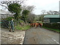
Moving the beasts
Yes the last animal is a bull - not counting the farmer!
Image: © Jonathan Billinger
Taken: 5 Feb 2008
0.08 miles
8
Watermill Walk west of Trewint
Here following the winding lane from Trecarne.
Image: © Derek Harper
Taken: 25 Jan 2017
0.14 miles
9
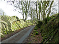
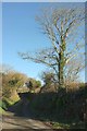
Steep-sided lane
East of Trecarne Farm.
Image: © Jonathan Billinger
Taken: 5 Feb 2008
0.17 miles
10
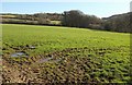
Field by the Watermill Walk
Looking right from where Image] was taken.
Image: © Derek Harper
Taken: 25 Jan 2017
0.19 miles