IMAGES TAKEN NEAR TO
Roughtor Road, CAMELFORD, PL32 9PS
Introduction
This page details the photographs taken nearby to Roughtor Road, PL32 9PS by members of the Geograph project.
The Geograph project started in 2005 with the aim of publishing, organising and preserving representative images for every square kilometre of Great Britain, Ireland and the Isle of Man.

There are currently over 7.5m images from over14,400 individuals and you can help contribute to the project by visiting https://www.geograph.org.uk
Image Map (Loading...)


Getting Data...Please wait
Leaflet Map data © OpenStreetMap
Images are licensed for reuse under creativecommons.org/licenses/by-sa/2.0
Notes
- Clicking on the map will re-center to the selected point.
- The higher the marker number, the further away the image location is from the centre of the postcode.
Image Listing (20 Images Found)
Images are licensed for reuse under creativecommons.org/licenses/by-sa/2.0
Image
Details
Distance
1
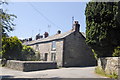
Tregoodwell Cottages
The village is a mix of granite cottages and modern houses.
Image: © Bill Harrison
Taken: 22 Jul 2012
0.04 miles
2
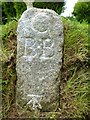
Old Boundary Marker
Parish Boundary Marker on the north side of the junction of Higher Cross Lane and an unclassified road. CAMELFORD parish. Inscribed C / B.B (possibly standing for Camelford Borough bounds). Grade II Listed https://historicengland.org.uk/listing/the-list/list-entry/1327661.
Milestone Society National ID: CW_CAMEL03pb
Image: © R Hanns
Taken: 25 Aug 2019
0.08 miles
3
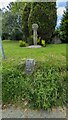
Boundary marker and cross at Tregoodwell
https://historicengland.org.uk/listing/the-list/list-entry/1327661?section=official-list-entry
Image: © Sandy Gerrard
Taken: 22 Jun 2024
0.08 miles
4
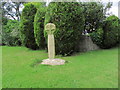
Tregoodwell Ancient Cross, Camelford
This cross has recently been restored to its original position
Image: © Colin Park
Taken: 12 Aug 2014
0.09 miles
5
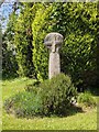
Old Wayside Cross in Tregoodwell, Camelford
Tregoodwell Cross, a wayside cross in the form of an old head in a new cross, which has been moved. Set in Tregoodwell on the northwest side of the road junction with Higher Cross Lane in Camelford parish. It had been moved and set up in Lanteglos by Camelford parish church. See also https://www.geograph.org.uk/photo/4285132.
Milestone Society National ID: CWNC_CAM04
Image: © L Nott
Taken: 24 Jun 2021
0.09 miles
7
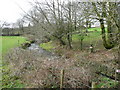
Tributary of the Camel
Unnamed river flowing south-west, away from camera, near Tregoodwell.
Image: © Jonathan Billinger
Taken: 5 Feb 2008
0.10 miles
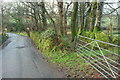
8
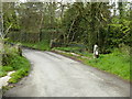
Bridge on Roughtor Road
Bridge over a tributary of the River Camel on the road from Camelford to Rough Tor and Bodmin Moor.
Image: © Philip Halling
Taken: 19 Feb 2012
0.11 miles
9
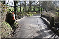
Lane approaching Tregoodwell
Dropping to cross a tributary of the Camel.
Image: © Derek Harper
Taken: 29 Jan 2018
0.13 miles
10
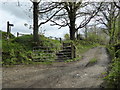
Public footpath from Tregoodwell to Moorgate
Image: © Rod Allday
Taken: 27 Apr 2014
0.14 miles