IMAGES TAKEN NEAR TO
Back Lane, BODMIN, PL31 2UT
Introduction
This page details the photographs taken nearby to Back Lane, PL31 2UT by members of the Geograph project.
The Geograph project started in 2005 with the aim of publishing, organising and preserving representative images for every square kilometre of Great Britain, Ireland and the Isle of Man.

There are currently over 7.5m images from over14,400 individuals and you can help contribute to the project by visiting https://www.geograph.org.uk
Image Map
Images are licensed for reuse under creativecommons.org/licenses/by-sa/2.0
Notes
- Clicking on the map will re-center to the selected point.
- The higher the marker number, the further away the image location is from the centre of the postcode.
Image Listing (8 Images Found)
Images are licensed for reuse under creativecommons.org/licenses/by-sa/2.0
Image
Details
Distance
2
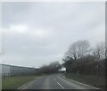
Bodmin : Launceston Road
The road heading out of Bodmin and past a retail park on the right.
Image: © Lewis Clarke
Taken: 23 Feb 2014
0.15 miles
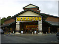
4
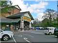
Morrisons, Bodmin
Originally built as a Safeway store, this has now been converted into a Morrisons following the recent takeover. This view was taken from the slope above the deliveries access road and gives some idea of the excavation of the hillside needed to provide the building area.
Image: © Phil Williams
Taken: 10 Oct 2005
0.21 miles
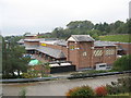
6
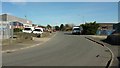
Cooksland Industrial Estate
The southern arm of the estate on the outskirts of Bodmin, from the same point as Image
Image: © Derek Harper
Taken: 25 Mar 2017
0.23 miles
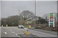
7
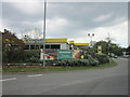
Morrisons petrol station on Priory Road, Bodmin
Image: © Ian S
Taken: 25 May 2013
0.24 miles
8
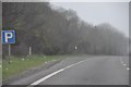
North Cornwall : The A30 Roadside
The roadside and a place for vehicles to stop on the A30.
Image: © Lewis Clarke
Taken: 23 Feb 2012
0.25 miles