IMAGES TAKEN NEAR TO
Gouda Close, BODMIN, PL31 2TG
Introduction
This page details the photographs taken nearby to Gouda Close, PL31 2TG by members of the Geograph project.
The Geograph project started in 2005 with the aim of publishing, organising and preserving representative images for every square kilometre of Great Britain, Ireland and the Isle of Man.

There are currently over 7.5m images from over14,400 individuals and you can help contribute to the project by visiting https://www.geograph.org.uk
Image Map
Images are licensed for reuse under creativecommons.org/licenses/by-sa/2.0
Notes
- Clicking on the map will re-center to the selected point.
- The higher the marker number, the further away the image location is from the centre of the postcode.
Image Listing (39 Images Found)
Images are licensed for reuse under creativecommons.org/licenses/by-sa/2.0
Image
Details
Distance
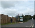
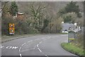
2
Junction of A389 with Boundary Road, Bodmin
Image: © David Smith
Taken: 7 Sep 2020
0.06 miles
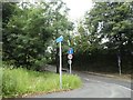
3
North Cornwall : The A389
At the road junction with Boundary Road and the A389.
Image: © Lewis Clarke
Taken: 23 Feb 2014
0.07 miles
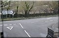
4
Dunmere : The A389
Looking along the A389 as it heads into Dunmere.
Image: © Lewis Clarke
Taken: 4 Jul 2011
0.08 miles
5
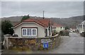
North Cornwall : Valley View Park
Valley View Park with some small houses near Bodmin.
Image: © Lewis Clarke
Taken: 23 Feb 2014
0.08 miles
6
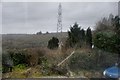
North Cornwall : Roadside Hedge
Looking towards a hedge and pylon in Cornwall.
Image: © Lewis Clarke
Taken: 23 Feb 2014
0.09 miles
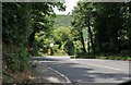
7
North Cornwall : The A389
The A389 heading through North Cornwall.
Image: © Lewis Clarke
Taken: 23 Feb 2014
0.10 miles
8
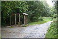
Rain Shelter on the Camel Trail
It's raining now but both me and the cyclist ahead are doing our best to ignore it!
Image: © Tony Atkin
Taken: 12 Sep 2008
0.13 miles
9
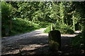
Cycleway Junction
Coming from the Bodmin spur to the Camel Trail, the track to the right takes you north to the upstream part of the Camel Trail while the main track to the left takes you onto the more popular downstream section towards Wadebridge and Padstow.
Image: © Tony Atkin
Taken: 12 Sep 2008
0.13 miles
10
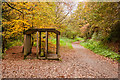
Shelter on the Camel Trail
A converted railway gangers' hut now serving as a shelter by the Camel Trail.
Image: © Guy Wareham
Taken: 14 Nov 2016
0.13 miles