IMAGES TAKEN NEAR TO
Boskear Lane, BODMIN, PL31 2RR
Introduction
This page details the photographs taken nearby to Boskear Lane, PL31 2RR by members of the Geograph project.
The Geograph project started in 2005 with the aim of publishing, organising and preserving representative images for every square kilometre of Great Britain, Ireland and the Isle of Man.

There are currently over 7.5m images from over14,400 individuals and you can help contribute to the project by visiting https://www.geograph.org.uk
Image Map
Images are licensed for reuse under creativecommons.org/licenses/by-sa/2.0
Notes
- Clicking on the map will re-center to the selected point.
- The higher the marker number, the further away the image location is from the centre of the postcode.
Image Listing (21 Images Found)
Images are licensed for reuse under creativecommons.org/licenses/by-sa/2.0
Image
Details
Distance
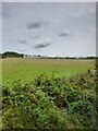
1
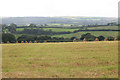
Straw bales in the field
Rural view taken near Bodmin looking down the valley towards the Camel.
Image: © roger geach
Taken: 9 Sep 2012
0.07 miles
2
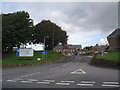
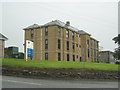
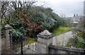
Bodmin Hospital
The entrance to Bodmin Hospital, currently undergoing an expansion programme.
Image: © Phil Williams
Taken: 9 Oct 2005
0.08 miles
3
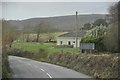
North Cornwall : Boundary Road
Looking along Boundary Road which is just outside of Bodmin.
Image: © Lewis Clarke
Taken: 23 Feb 2014
0.10 miles
5
Nurses' accommodation block at Bodmin Hospital
Image: © Rod Allday
Taken: 26 Jul 2009
0.14 miles
6
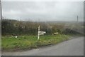
North Cornwall : Stony Lane Signpost
A signpost giving directions to Wadebridge and Camelford.
Image: © Lewis Clarke
Taken: 23 Feb 2014
0.15 miles
7
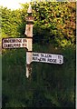
Old Direction Sign - Signpost by Stony Lane, Luxulyan parish
No finial - by the UC road, in parish of Luxulyan (Restormel District), T-junction, on verge at Stony Lane junction with Boskear Lane.
Surveyed
Milestone Society National ID: CW_SX0566B
Image: © Milestone Society
Taken: Unknown
0.16 miles
8

Old Direction Sign - Signpost by Stony Lane, Bodmin
Pyramid finial - Top arm broken off at sleeve; Visick casting by the UC road, in parish of Bodmin (North Cornwall District), on verge at junction of Boskear Lane with Stony Lane and Boundary Road.
Cornwall & Scilly HER.
HER Number: MCO56950 https://www.heritagegateway.org.uk/Gateway/Results_Single.aspx?uid=MCO56950&resourceID=1020
Surveyed
Milestone Society National ID: CW_SX0566A
Image: © Milestone Society
Taken: Unknown
0.16 miles
9
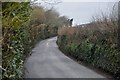
North Cornwall : Boundary Road
Boundary Road heading towards Dunmere Road.
Image: © Lewis Clarke
Taken: 23 Feb 2014
0.18 miles
10
North Cornwall : Hendorgor House
A house just outside of Bodmin.
Image: © Lewis Clarke
Taken: 23 Feb 2014
0.18 miles