IMAGES TAKEN NEAR TO
Ringway, BODMIN, PL31 2LT
Introduction
This page details the photographs taken nearby to Ringway, PL31 2LT by members of the Geograph project.
The Geograph project started in 2005 with the aim of publishing, organising and preserving representative images for every square kilometre of Great Britain, Ireland and the Isle of Man.

There are currently over 7.5m images from over14,400 individuals and you can help contribute to the project by visiting https://www.geograph.org.uk
Image Map (Loading...)


Getting Data...Please wait
Leaflet Map data © OpenStreetMap
Images are licensed for reuse under creativecommons.org/licenses/by-sa/2.0
Notes
- Clicking on the map will re-center to the selected point.
- The higher the marker number, the further away the image location is from the centre of the postcode.
Image Listing (103 Images Found)
Images are licensed for reuse under creativecommons.org/licenses/by-sa/2.0
Image
Details
Distance
2
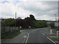
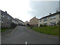
Bodmin : Dennison Road
Dennison Road heading through Bodmin on the A389.
Image: © Lewis Clarke
Taken: 23 Feb 2014
0.02 miles
3
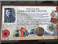
Origin of the name 'Finn VC Estate', Bodmin
This information board is by the road through the estate, between Dennison Road and Lower Bore Street. It tells how Bodmin boy James Henry Finn won the Victoria Cross for his selfless bravery on 9 April 1916.
Image: © Robin Stott
Taken: 16 Mar 2015
0.03 miles
4
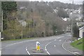
Bodmin : Dennison Road
Dennison Road heading through the town of Bodmin.
Image: © Lewis Clarke
Taken: 23 Feb 2014
0.04 miles
6
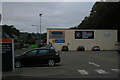
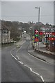
Bodmin: east end of Sainsbury's car park
Image: © Christopher Hilton
Taken: 27 Oct 2016
0.04 miles
7
Site of Bodmin North Station
See Image] for a 50 year comparison.
Image: © Ashley Dace
Taken: 18 Mar 2013
0.05 miles
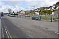
8
Sainsbury's car park and the fire station, Brownlow Place, Bodmin
Wallace Road winds up the hill, centre background.
Image: © Robin Stott
Taken: 16 Mar 2015
0.05 miles
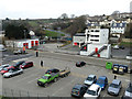
9
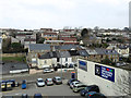
End of Sainsbury's car park and Brownlow Place, Bodmin
Housing on the hillside is reached from Berrycombe Road, Wallace Road and Harmer Close.
Image: © Robin Stott
Taken: 16 Mar 2015
0.06 miles
10
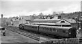
Bodmin North Station
View NW: buffer-stops right, Wadebridge left; ex-LSW terminus of branch from Wadebridge, closed completely 30/1/67. Local train for Wadebridge and Padstow in platform, headed by an LMS-type Ivatt Class 2 2-6-2T.
Image: © Ben Brooksbank
Taken: 20 Apr 1964
0.06 miles