IMAGES TAKEN NEAR TO
Church Square, BODMIN, PL31 2LR
Introduction
This page details the photographs taken nearby to Church Square, PL31 2LR by members of the Geograph project.
The Geograph project started in 2005 with the aim of publishing, organising and preserving representative images for every square kilometre of Great Britain, Ireland and the Isle of Man.

There are currently over 7.5m images from over14,400 individuals and you can help contribute to the project by visiting https://www.geograph.org.uk
Image Map
Images are licensed for reuse under creativecommons.org/licenses/by-sa/2.0
Notes
- Clicking on the map will re-center to the selected point.
- The higher the marker number, the further away the image location is from the centre of the postcode.
Image Listing (149 Images Found)
Images are licensed for reuse under creativecommons.org/licenses/by-sa/2.0
Image
Details
Distance
1
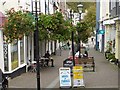
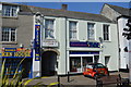
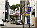
Honey Street, Bodmin
A pedestrianised street.
Image: © John Lucas
Taken: 6 Jun 2006
0.02 miles
2
Bodmin Band Club - Honey Street
Former Territorial Force drill hall pre WW1.
Image: © John M
Taken: 7 Sep 2014
0.02 miles
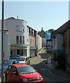
3
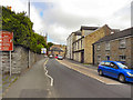
Dennison Street
The A389, approaching Bodmin town centre.
Image: © David Dixon
Taken: 26 Jul 2010
0.02 miles
4
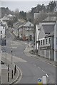
Bodmin : Crinnick's Hill
Looking up towards the hillside which is lined with houses and buildings.
Image: © Lewis Clarke
Taken: 23 Feb 2014
0.02 miles
5
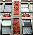
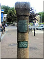
Terracotta detail
On a building in Honey Street, Bodmin.
Image: © Jonathan Billinger
Taken: 30 Mar 2009
0.03 miles
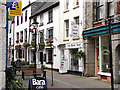
7
Crockwell Street, Bodmin
With The Piazza, a mixed development including a shopping mall, on the left.
Image: © Derek Harper
Taken: 16 Aug 2016
0.03 miles