IMAGES TAKEN NEAR TO
Dennison Road, BODMIN, PL31 2LL
Introduction
This page details the photographs taken nearby to Dennison Road, PL31 2LL by members of the Geograph project.
The Geograph project started in 2005 with the aim of publishing, organising and preserving representative images for every square kilometre of Great Britain, Ireland and the Isle of Man.

There are currently over 7.5m images from over14,400 individuals and you can help contribute to the project by visiting https://www.geograph.org.uk
Image Map
Images are licensed for reuse under creativecommons.org/licenses/by-sa/2.0
Notes
- Clicking on the map will re-center to the selected point.
- The higher the marker number, the further away the image location is from the centre of the postcode.
Image Listing (162 Images Found)
Images are licensed for reuse under creativecommons.org/licenses/by-sa/2.0
Image
Details
Distance
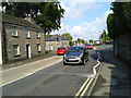
2
Houses on Dennison Road, Bodmin
A terrace of three just west of Mill Street, with a Domino pizza outlet close by.
Image: © Derek Harper
Taken: 16 Aug 2016
0.02 miles
3
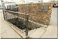
The Eye Well / Bree Shute Well
Grade II listed spring on Bell Lane with a datestone of 1700
The well had a reputation for healing weak and troubled eyes as well as being a local water supply.
Image: © Richard Croft
Taken: 5 Sep 2022
0.03 miles
4
The Eye Well
Dated 1700 on a stone tablet, the well was also known as Bree Shute Well, a public water source. It had a reputation for healing weak and troubled eyes. Although described as 'a fairly good water' in a Rivers Commission report in 1872, an analysis showed the water to be contaminated and a possible source of fatal illnesses.
Image: © Rod Allday
Taken: 22 Sep 2010
0.03 miles
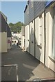
5

Market Street, Bodmin
A narrow street from Fore Street dropping down to meet Dennison Road.
Image: © Derek Harper
Taken: 16 Aug 2016
0.04 miles
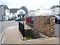
6
Bell Lane, Bodmin
An alley seen from Fore Street. The building you can see at the bottom of the alley with a half-hipped roof is the Stillmoor House Medical Practice.
Image: © Derek Harper
Taken: 16 Aug 2016
0.04 miles
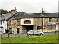
7
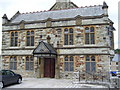
Bodmin Public Rooms
Next door to the Shire Hall. Used for various public events and at one time the scene of lively Saturday night dances when Bodmin had a large military presence.
Image: © Michael Pierce
Taken: 26 Jun 2007
0.05 miles
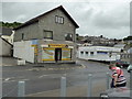
8
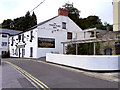
The White Hart Inn
Pool Street, Bodmin.
Image: © David Dixon
Taken: 26 Jul 2010
0.05 miles