IMAGES TAKEN NEAR TO
Tradewinds Close, BODMIN, PL31 2FT
Introduction
This page details the photographs taken nearby to Tradewinds Close, PL31 2FT by members of the Geograph project.
The Geograph project started in 2005 with the aim of publishing, organising and preserving representative images for every square kilometre of Great Britain, Ireland and the Isle of Man.

There are currently over 7.5m images from over14,400 individuals and you can help contribute to the project by visiting https://www.geograph.org.uk
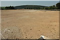
Image Map
Images are licensed for reuse under creativecommons.org/licenses/by-sa/2.0
Notes
- Clicking on the map will re-center to the selected point.
- The higher the marker number, the further away the image location is from the centre of the postcode.
Image Listing (26 Images Found)
Images are licensed for reuse under creativecommons.org/licenses/by-sa/2.0
Image
Details
Distance
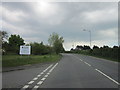
2
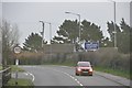
Welcome to Bodmin
A view looking to the southeast along the A389 on approach to Bodmin.
Image: © Phil Williams
Taken: 25 Mar 2007
0.05 miles
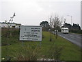
3
By the A389 west of Bodmin
Dunmere Road heads towards Bodmin past out-of-town developments, with the car park to Home Bargains Image] on the immediate left, followed by Jewson / Graham.
Image: © Derek Harper
Taken: 16 Aug 2016
0.08 miles
4

Home Bargains, Bodmin
The spirit of Roy Lichtenstein lives on at a new store on the outskirts of Bodmin.
Image: © Derek Harper
Taken: 16 Aug 2016
0.08 miles
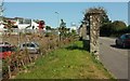
5
Home Bargains, Bodmin
This is Dunmere Road Retail Park. An Aldi was due to be built in the space on the left, but now seems to have changed its mind and be heading elsewhere in the town.
Image: © Derek Harper
Taken: 16 Aug 2016
0.09 miles
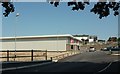
6
Dunmere Road Retail Park
A vacant site beside Home Bargains. A little research suggests that this was earmarked for an Aldi store, but they are heading for a different site.
Image: © Derek Harper
Taken: 16 Aug 2016
0.09 miles
7
North Cornwall : The A389
The A389 as it heads towards Bodmin from Wadebridge.
Image: © Lewis Clarke
Taken: 23 Feb 2014
0.10 miles
8
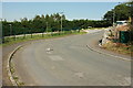
Midway Road, Bodmin
Curving round behind Dunmere Road Retail Park.
Image: © Derek Harper
Taken: 16 Aug 2016
0.11 miles
9
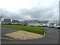
New housing estate and further construction, Bodmin
Image: © David Smith
Taken: 7 Sep 2020
0.12 miles
10

Old Direction Sign - Signpost by Stony Lane, Bodmin
Pyramid finial - Top arm broken off at sleeve; Visick casting by the UC road, in parish of Bodmin (North Cornwall District), on verge at junction of Boskear Lane with Stony Lane and Boundary Road.
Cornwall & Scilly HER.
HER Number: MCO56950 https://www.heritagegateway.org.uk/Gateway/Results_Single.aspx?uid=MCO56950&resourceID=1020
Surveyed
Milestone Society National ID: CW_SX0566A
Image: © Milestone Society
Taken: Unknown
0.14 miles