IMAGES TAKEN NEAR TO
Withiel, BODMIN, PL30 5PB
Introduction
This page details the photographs taken nearby to PL30 5PB by members of the Geograph project.
The Geograph project started in 2005 with the aim of publishing, organising and preserving representative images for every square kilometre of Great Britain, Ireland and the Isle of Man.

There are currently over 7.5m images from over14,400 individuals and you can help contribute to the project by visiting https://www.geograph.org.uk
Image Map (Loading...)


Getting Data...Please wait
Leaflet Map data © OpenStreetMap
Images are licensed for reuse under creativecommons.org/licenses/by-sa/2.0
Notes
- Clicking on the map will re-center to the selected point.
- The higher the marker number, the further away the image location is from the centre of the postcode.
Image Listing (7 Images Found)
Images are licensed for reuse under creativecommons.org/licenses/by-sa/2.0
Image
Details
Distance
1
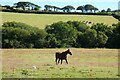
Pasture, Withiel
Beside the footpath that heads south from Lanjew.
Image: © Andrew Smith
Taken: 9 Jul 2022
0.07 miles
3
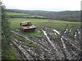
Field near Lanjew
Footpath 565/10/1 passes a vehicle that's seen better days as it enters a field on the way to Prince Park.
Image: © Derek Harper
Taken: 17 Dec 2009
0.12 miles
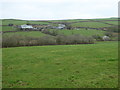
4
Hay Meadow by Lanjew Farm
Taken walking down through the meadow towards the strip of woodland by Prince Park
Image: © Sheila Russell
Taken: 26 Jul 2005
0.14 miles
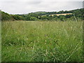
7
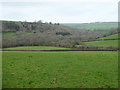
Mixed woodland in the valley near Prince Park
Image: © Rod Allday
Taken: 19 Mar 2017
0.24 miles