IMAGES TAKEN NEAR TO
Greenacres, BODMIN, PL30 5LZ
Introduction
This page details the photographs taken nearby to Greenacres, PL30 5LZ by members of the Geograph project.
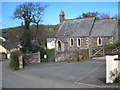
The Geograph project started in 2005 with the aim of publishing, organising and preserving representative images for every square kilometre of Great Britain, Ireland and the Isle of Man.

There are currently over 7.5m images from over14,400 individuals and you can help contribute to the project by visiting https://www.geograph.org.uk
Image Map (Loading...)


Getting Data...Please wait
Leaflet Map data © OpenStreetMap
Images are licensed for reuse under creativecommons.org/licenses/by-sa/2.0
Notes
- Clicking on the map will re-center to the selected point.
- The higher the marker number, the further away the image location is from the centre of the postcode.
Image Listing (24 Images Found)
Images are licensed for reuse under creativecommons.org/licenses/by-sa/2.0
Image
Details
Distance
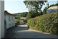
2
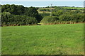
Fields, Nanstallon
From a lane that forms the northern side of a triangle of roads, looking over the Camel valley.
Image: © Derek Harper
Taken: 16 Aug 2016
0.07 miles
3
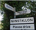
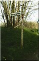
Old Direction Sign - Signpost by Nanstallon village
No finial - 2 arms; by the UC road, in parish of Lanivet (North Cornwall District), at fork in road at Nanstallon, behind Nanstallon village sign.
Surveyed
Milestone Society National ID: CW_SX0467A
Image: © Milestone Society
Taken: Unknown
0.11 miles
4
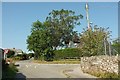
Crossroads, Nanstallon
On the south side of the village.
Image: © Derek Harper
Taken: 16 Aug 2016
0.13 miles
6
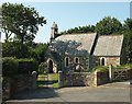
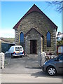
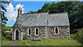
Church of St Stephens, Nanstallon
A very similar, but summer, view to Image
Image: © Derek Harper
Taken: 16 Aug 2016
0.14 miles
8
Old Direction Sign - Signpost by Nanstallon, Lanivet parish
Cone finial - not original arm; by the UC road, in parish of Lanivet (North Cornwall District), T-junction with private lane to station, on verge.
Surveyed
Milestone Society National ID: CW_SX0467
Image: © Milestone Society
Taken: Unknown
0.14 miles
10
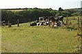
Cattle, Nanstallon
Opposite the school, and above the valley of a tributary of the Camel.
Image: © Derek Harper
Taken: 16 Aug 2016
0.17 miles