IMAGES TAKEN NEAR TO
Lanivet, BODMIN, PL30 5JJ
Introduction
This page details the photographs taken nearby to PL30 5JJ by members of the Geograph project.
The Geograph project started in 2005 with the aim of publishing, organising and preserving representative images for every square kilometre of Great Britain, Ireland and the Isle of Man.

There are currently over 7.5m images from over14,400 individuals and you can help contribute to the project by visiting https://www.geograph.org.uk
Image Map
Images are licensed for reuse under creativecommons.org/licenses/by-sa/2.0
Notes
- Clicking on the map will re-center to the selected point.
- The higher the marker number, the further away the image location is from the centre of the postcode.
Image Listing (4 Images Found)
Images are licensed for reuse under creativecommons.org/licenses/by-sa/2.0
Image
Details
Distance
1
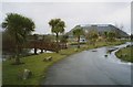
Lakeview Park Country Club, Lanivet
"All this was fields..." The palm trees are to remind us of the Mediterranean (pity about the weather), the stones are to keep cars on the drive.
Image: © Humphrey Bolton
Taken: 9 Mar 2001
0.03 miles
2
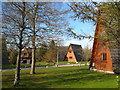
A frame holiday lodges at Lakeview
A modern development centred around man-made fishing lakes.
Image: © Rod Allday
Taken: 11 Apr 2010
0.07 miles
3
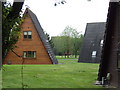
Chalets at Lakeview Country Club
In the ski-lodge style!
Image: © Jonathan Billinger
Taken: 9 May 2007
0.09 miles
4
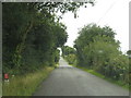
The old coach road
In times past this was the main road from west Cornwall to Bodmin, the County Town, and thence to the rest of the world. It was superseded by the A30 via Innis Downs, which has itself in recent years been replaced by the new dual carriageway road.
Image: © Rod Allday
Taken: 26 Jul 2009
0.23 miles