IMAGES TAKEN NEAR TO
Parc Vean, BODMIN, PL30 5GD
Introduction
This page details the photographs taken nearby to Parc Vean, PL30 5GD by members of the Geograph project.
The Geograph project started in 2005 with the aim of publishing, organising and preserving representative images for every square kilometre of Great Britain, Ireland and the Isle of Man.

There are currently over 7.5m images from over14,400 individuals and you can help contribute to the project by visiting https://www.geograph.org.uk
Image Map
Images are licensed for reuse under creativecommons.org/licenses/by-sa/2.0
Notes
- Clicking on the map will re-center to the selected point.
- The higher the marker number, the further away the image location is from the centre of the postcode.
Image Listing (9 Images Found)
Images are licensed for reuse under creativecommons.org/licenses/by-sa/2.0
Image
Details
Distance
1
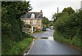
Nanstallon Village
Unspoilt village in the Camel Valley , not far from Bodmin Town.
Image: © roger geach
Taken: 23 Sep 2010
0.04 miles
2
Small tributary of the Camel at Nanstallon
Looking downstream.
Image: © Rod Allday
Taken: 11 Apr 2010
0.08 miles
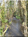
3
Bridge over a small stream at Nanstallon.
Image: © Rod Allday
Taken: 11 Apr 2010
0.08 miles
4
Nanstallon Primary School
A view looking to the northwest towards the primary school at Nanstallon.
Image: © Phil Williams
Taken: 25 Mar 2007
0.10 miles
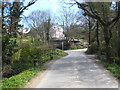
5
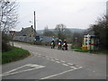
Crossroads at Nanstallon
A view looking to the southwest at a crossroads at Nanstallon, with the primary school building on the left. The gentlemen on the trials bikes spent some time discussing routes, and then headed off the way they had come, back down the lane to Threewaters.
Image: © Phil Williams
Taken: 25 Mar 2007
0.10 miles
6
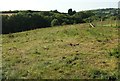
Pasture, Nanstallon
Looking right from the same spot as Image
Image: © Derek Harper
Taken: 16 Aug 2016
0.10 miles
7
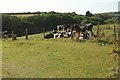
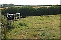
Cattle, Nanstallon
Opposite the school, and above the valley of a tributary of the Camel.
Image: © Derek Harper
Taken: 16 Aug 2016
0.10 miles
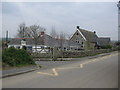
8
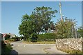
Crossroads, Nanstallon
On the south side of the village.
Image: © Derek Harper
Taken: 16 Aug 2016
0.13 miles
9
Cattle, Nanstallon
Cattle pasture above the valley of a tributary of the Camel. The cattle also appear in Image
Image: © Derek Harper
Taken: 16 Aug 2016
0.13 miles