IMAGES TAKEN NEAR TO
Lanlivery, BODMIN, PL30 5DB
Introduction
This page details the photographs taken nearby to PL30 5DB by members of the Geograph project.
The Geograph project started in 2005 with the aim of publishing, organising and preserving representative images for every square kilometre of Great Britain, Ireland and the Isle of Man.

There are currently over 7.5m images from over14,400 individuals and you can help contribute to the project by visiting https://www.geograph.org.uk
Image Map
Images are licensed for reuse under creativecommons.org/licenses/by-sa/2.0
Notes
- Clicking on the map will re-center to the selected point.
- The higher the marker number, the further away the image location is from the centre of the postcode.
Image Listing (3 Images Found)
Images are licensed for reuse under creativecommons.org/licenses/by-sa/2.0
Image
Details
Distance
1
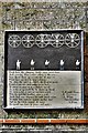
Lanlivery, St. Brevita's Church: The bell ringers rhyme
Image: © Michael Garlick
Taken: 27 Jun 2019
0.07 miles
2
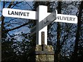
Old Direction Sign - Signpost near Lower Pennant, Lanlivery parish
Pyramid finial - 4 arms; by the UC road, in parish of Lanlivery (Restormel District), crossroads near Lower Pennant, on verge diagonally opposite house.
Surveyed
Milestone Society National ID: CW_SX0759A
Image: © Milestone Society
Taken: Unknown
0.11 miles
3
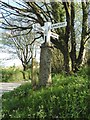
Signpost by the Saints' Way near Lanlivery
Image: © Dave Kelly
Taken: 26 Apr 2017
0.11 miles