IMAGES TAKEN NEAR TO
Lanlivery, BODMIN, PL30 5BX
Introduction
This page details the photographs taken nearby to PL30 5BX by members of the Geograph project.
The Geograph project started in 2005 with the aim of publishing, organising and preserving representative images for every square kilometre of Great Britain, Ireland and the Isle of Man.

There are currently over 7.5m images from over14,400 individuals and you can help contribute to the project by visiting https://www.geograph.org.uk
Image Map
Images are licensed for reuse under creativecommons.org/licenses/by-sa/2.0
Notes
- Clicking on the map will re-center to the selected point.
- The higher the marker number, the further away the image location is from the centre of the postcode.
Image Listing (3 Images Found)
Images are licensed for reuse under creativecommons.org/licenses/by-sa/2.0
Image
Details
Distance
1
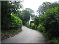
Poltip Cottage
A view looking southeast along the lane from Lanlivery to the A390, towards Poltip Cottage.
Image: © Phil Williams
Taken: 3 Jul 2006
0.06 miles
2
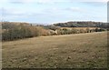
Field at Lanlivery
The valley between the field and the houses around the A380 at Pelyndowns is of a tributary of the Fowey.
Image: © Derek Harper
Taken: 13 Mar 2010
0.15 miles
3
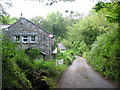
Puddle
A view looking north along the lane through Puddle to Lanlivery, towards the bridge over the stream, with Puddle Cottage on the left.
Image: © Phil Williams
Taken: 2 Jul 2006
0.20 miles