IMAGES TAKEN NEAR TO
Treffry Lane, BODMIN, PL30 5AF
Introduction
This page details the photographs taken nearby to Treffry Lane, PL30 5AF by members of the Geograph project.
The Geograph project started in 2005 with the aim of publishing, organising and preserving representative images for every square kilometre of Great Britain, Ireland and the Isle of Man.

There are currently over 7.5m images from over14,400 individuals and you can help contribute to the project by visiting https://www.geograph.org.uk
Image Map
Images are licensed for reuse under creativecommons.org/licenses/by-sa/2.0
Notes
- Clicking on the map will re-center to the selected point.
- The higher the marker number, the further away the image location is from the centre of the postcode.
Image Listing (12 Images Found)
Images are licensed for reuse under creativecommons.org/licenses/by-sa/2.0
Image
Details
Distance

3
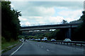
The A30
Bridge carrying the B3268 at Treffrey.
Image: © Robert Ashby
Taken: 23 Aug 2014
0.19 miles
4
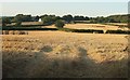
Harvested fields, Treffry
From further up the lane shown in Image], looking left, with houses along Treffry Lane.
Image: © Derek Harper
Taken: 16 Aug 2016
0.20 miles
5
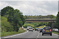
Cornwall : The A30
Looking along the A30 as it heads through Cornwall.
Image: © Lewis Clarke
Taken: 17 Jul 2015
0.20 miles
6
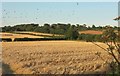
Harvested fields, Treffry
Looking right from where Image] was taken, with some overlap and a flock of birds - presumably rooks - taking to the air.
Image: © Derek Harper
Taken: 16 Aug 2016
0.21 miles
7

Bales, Treffry
Looking more to the left than Image], with overlap, plus part of the flock of birds also seen in Image
Image: © Derek Harper
Taken: 16 Aug 2016
0.22 miles
8

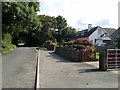
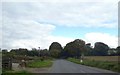
Treffry Lane
Buildings at Treffry can be seen in the background. This was taken a little up the road from Image], used by NCN3.
Image: © Derek Harper
Taken: 16 Aug 2016
0.22 miles
10
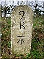
Old Milestone by the B3268, west of Lanhydrock
Carved stone post by the B3268, in parish of LANHYDROCK (NORTH CORNWALL District), Treffry, South of flyover over A30, on the verge, on West side of road. Bodmin 'B' Gravestone, erected by the Bodmin turnpike trust in the 18th century.
Inscription reads:-
2
B
Carved benchmark on lower front face.
Grade II listed.
List Entry Number: 1327933 https://historicengland.org.uk/listing/the-list/list-entry/1327933
Milestone Society National ID: CW_BMLS02.
Image: © Rosy Hanns
Taken: 22 Mar 2019
0.24 miles