IMAGES TAKEN NEAR TO
St. Breward, BODMIN, PL30 4LX
Introduction
This page details the photographs taken nearby to PL30 4LX by members of the Geograph project.
The Geograph project started in 2005 with the aim of publishing, organising and preserving representative images for every square kilometre of Great Britain, Ireland and the Isle of Man.

There are currently over 7.5m images from over14,400 individuals and you can help contribute to the project by visiting https://www.geograph.org.uk
Image Map
Images are licensed for reuse under creativecommons.org/licenses/by-sa/2.0
Notes
- Clicking on the map will re-center to the selected point.
- The higher the marker number, the further away the image location is from the centre of the postcode.
Image Listing (12 Images Found)
Images are licensed for reuse under creativecommons.org/licenses/by-sa/2.0
Image
Details
Distance
1
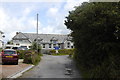
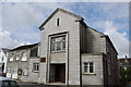
St Breward Primary School
Built 1930. The granite was probably quarried in the village.
Image: © Bill Harrison
Taken: 15 Jul 2012
0.07 miles
2
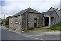
The Home of St Breward Silver Band
The St Breward Silver Band was formed in 1899. During the Summer months you are most likely to see them playing at Port Isaac. You can find a list of performance dates at http://www.stbrewardband.co.uk/events/index.asp
Image: © Tony Atkin
Taken: 23 Jul 2010
0.16 miles
3
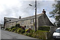
Terraced cottages, St Breward
For a comprehensive description of the history and architecture of Cornwall's highest village, see: http://www.historic-cornwall.org.uk/cisi/st_breward/cisi_st_breward_report.pdf
Image: © Bill Harrison
Taken: 15 Jul 2012
0.18 miles
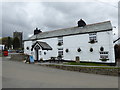
4
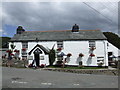
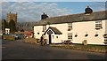
Old Inn, St Breward
Nice little pub with the emphasis on Sharps beers in Cornwall's highest village.
Image: © al partington
Taken: 30 Jul 2006
0.18 miles
5
St Breward Methodist Church
Dating from as recently as 1957, replacing the chapel destroyed in World War II by a German bomb (see: http://www.bbc.co.uk/history/ww2peopleswar/stories/31/a8346431.shtml ).
Image: © Bill Harrison
Taken: 15 Jul 2012
0.20 miles
6
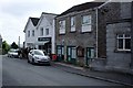
St Breward Village Store
A group of walkers take the opportunity to buy refreshments.
Image: © Tony Atkin
Taken: 23 Jul 2010
0.20 miles
7
Pub and church, St Breward Churchtown
The Old Inn is also shown at Image, the grade I listed St Brueredus Church https://www.historicengland.org.uk/listing/the-list/list-entry/1158842 at http://www.geograph.org.uk/search.php?i=72517087 . In front of the pub is the cross https://www.historicengland.org.uk/listing/the-list/list-entry/1158888 .
Image: © Derek Harper
Taken: 22 Jan 2017
0.22 miles
8
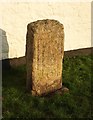
Cross, St Breward Churchtown
The listed granite monolith is also visible at Image "Rectangular shaft with moulded corners carved on both faces and sides, the carving partly eroded and difficult to distinguish."
Image: © Derek Harper
Taken: 22 Jan 2017
0.22 miles
10
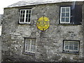
Old Sign on Old Building
Both the building and the sign require tlc. The AA put these signs up in some out of the way places.
Image: © Martin Dawes
Taken: 13 Jun 2009
0.23 miles