IMAGES TAKEN NEAR TO
Blisland, BODMIN, PL30 4LQ
Introduction
This page details the photographs taken nearby to PL30 4LQ by members of the Geograph project.
The Geograph project started in 2005 with the aim of publishing, organising and preserving representative images for every square kilometre of Great Britain, Ireland and the Isle of Man.

There are currently over 7.5m images from over14,400 individuals and you can help contribute to the project by visiting https://www.geograph.org.uk
Image Map (Loading...)


Getting Data...Please wait
Leaflet Map data © OpenStreetMap
Images are licensed for reuse under creativecommons.org/licenses/by-sa/2.0
Notes
- Clicking on the map will re-center to the selected point.
- The higher the marker number, the further away the image location is from the centre of the postcode.
Image Listing (9 Images Found)
Images are licensed for reuse under creativecommons.org/licenses/by-sa/2.0
Image
Details
Distance
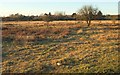
1
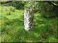
Estate Boundary Marker in Penquite Marsh, Blisland parish
Estate Boundary Marker on the western edge of the marshland known as Penquite Marsh 130 metres west of the lane to Delford Bridge. Blisland parish.
The 1842 Tithe map shows a series of stones separating Kerrow Downs and Penquite Marsh from an area to the north known formerly as Black Downs or Blackpool. With the exception of one stone, now thought to be used as a gatepost to a field to the east, all these survive, although Black Downs is now simply known as part of Kerrow Downs. Records show that Sir William Molesworth was in 1842 the Lord of the Manor of Blisland and owned Kerrow Downs and part of Penquite Marsh. His mark MX is carved on the southern face of this stone. Records also show that Black Downs was at this time owned by John Wallis and his mark W is carved on the stone’s northern face. Subsequently Black Downs was acquired by James Hayward, and his letter H was added to this stone at a later date.
Milestone Society National ID: CW_BLIS50em
Image: © P G Moore
Taken: Unknown
0.10 miles
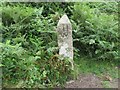
2
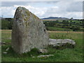
Standing Stone
Stone at top of field in South Penquite Farm (campsite).
Image: © helen miller
Taken: 24 Jul 2007
0.10 miles
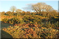
3

South Penquite campsite
Evening on a quiet corner of the campsite at the end of summer.
The field is edged by Cornish hedges - turf-covered walls with the trees or shrubs growing at the top.
Image: © Pauline W
Taken: 15 Sep 2009
0.11 miles
4
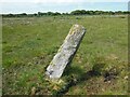
Estate Boundary Marker in Penquite Marsh, Blisland parish
Estate Boundary Marker clearly visible in the open marshland known as Penquite Marsh 45 metres west of the lane to Delford Bridge. Blisland parish.
The 1842 Tithe map shows a series of stones separating Kerrow Downs and Penquite Marsh from an area to the north known formerly as Black Downs or Blackpool. With the exception of one stone, now thought to be used as a gatepost to a field to the east, all these survive, although Black Downs is now simply known as part of Kerrow Downs. Records show that Sir William Molesworth was in 1842 the Lord of the Manor of Blisland and owned Kerrow Downs and part of Penquite Marsh. His mark MX is carved on the southern face of this stone. Records also show that Black Downs was at this time owned by John Wallis and his mark W is carved on the stone’s northern face. Subsequently Black Downs was acquired by James Hayward, and his letter H was added to this stone at a later date.
Milestone Society National ID: CW_BLIS49em
Image: © P G Moore
Taken: Unknown
0.16 miles
5
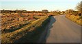
Road across Pendrift Downs
Looking right from where Image] was taken. Just around the bend is a left turn into Black Penquite. NCN3 follows the road.
Image: © Derek Harper
Taken: 25 Jan 2017
0.18 miles
6
Pendrift Downs #3
From NCN3 looking towards South Penquite, in Image
Image: © Derek Harper
Taken: 25 Jan 2017
0.18 miles
7
Estate Boundary Marker on Kerrow Downs in Blisland parish
Estate Boundary Marker on the west side of the lane to Delford Bridge opposite the track leading to Black Penquite. Blisland parish.
The 1842 Tithe map shows a series of stones separating Kerrow Downs and Penquite Marsh from an area to the north known formerly as Black Downs or Blackpool. With the exception of one stone, now thought to be used as a gatepost to a field to the east, all these survive, although Black Downs is now simply known as part of Kerrow Downs. Records show that Sir William Molesworth was in 1842 the Lord of the Manor of Blisland and owned Kerrow Downs and part of Penquite Marsh. His mark MX is carved on the southern face of this stone. Records also show that Black Downs was at this time owned by John Wallis and his mark W is carved on the stone’s northern face. Subsequently Black Downs was acquired by James Hayward, and his letter H was added to this stone at a later date.
Milestone Society National ID: CW_BLIS48em
Image: © P G Moore
Taken: Unknown
0.18 miles
8
Pendrift Downs #4
The northeastern corner of the access land, looking right from where Image] was taken.
Image: © Derek Harper
Taken: 25 Jan 2017
0.22 miles
9
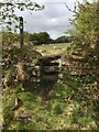
Stone Stile SX1074
North of Jubilee Rock, and west of South Penquite Farm.
North and South Sides: 2 steps topped with a similar piece of granite.
Like several other walks in the parish, this footpath, and the stile, would have given a shortcut from parts of Blisland parish to the de Lank Quarry and St Breward beyond.
FP No. 503/5/1, 2, 4 leads from the Carwen road junction above Lease, across Pendrift Downs via Jubilee Rock, to the eastern edge of the de Lank Quarry and the boundary with St. Breward parish.
Image: © Anne Green
Taken: 15 May 2021
0.24 miles